Mobility Interface
A spatial research area devoted to examining the relationships between mobility, the waterfront, port infrastructure, pedestrian and vehicle circulation, urban connections, and spatial experience in Fontvieille.
Urban Mobility · Mobility Interface · Port-City Relations · Pedestrian Circulation · Maritime Landscape · Spatial Connectivity · Waterfront · Visual Fieldwork
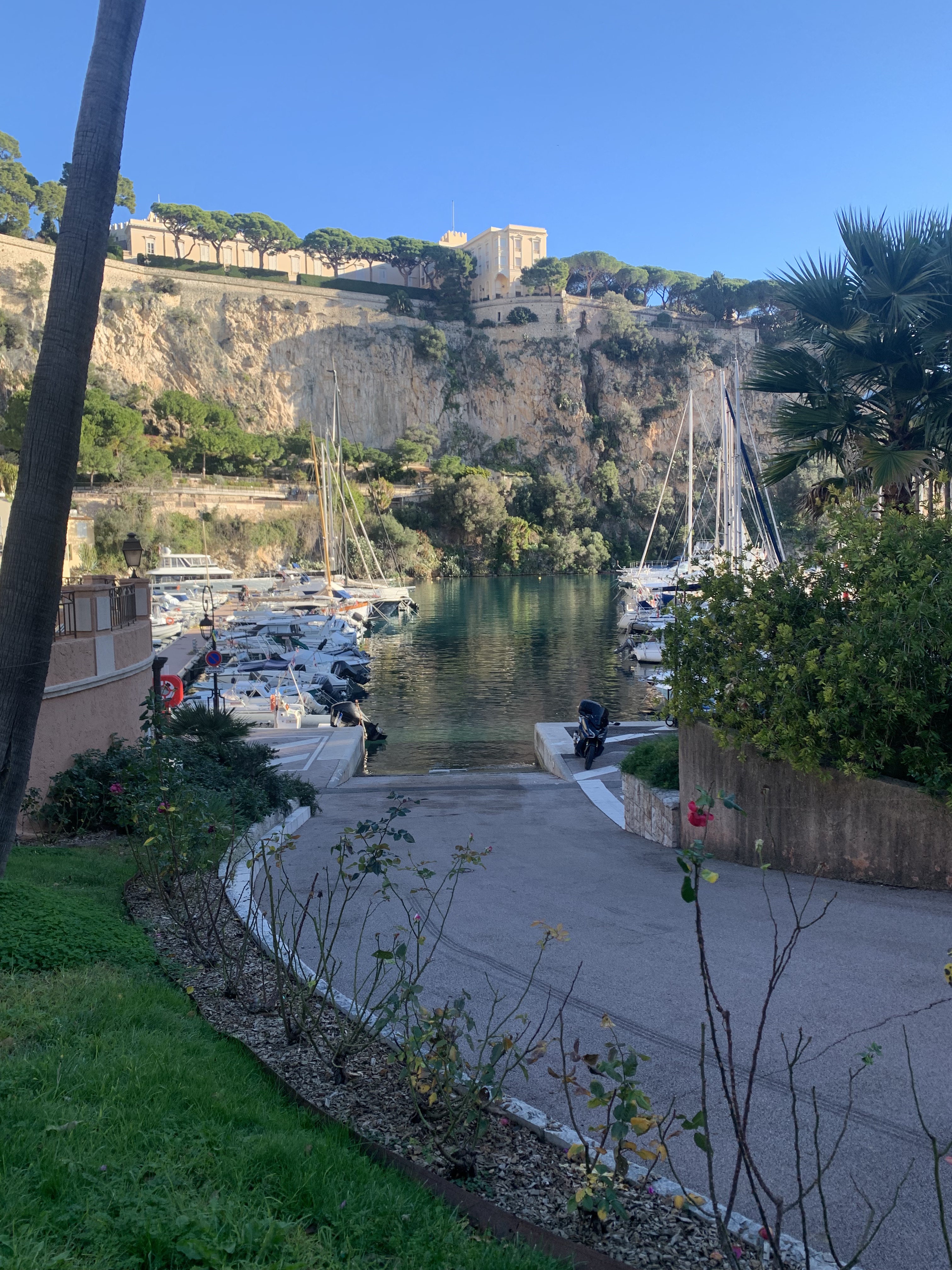
Location: Fontvieille · Monaco
Visual source: Monaco Visual Fieldwork Archive (MVFA)
Fieldwork: 2017–2026
Photography: © Xavier Reinaldo-Virgili
Description: Contextual view of Fontvieille used to document the relationship between the urban fabric, infrastructure, mobility, and the maritime landscape.
Research use: Spatial Context · Mobility Interface · Waterfront · Port-City Relations
Research Area Fontvieille as an Urban Mobility Interface
Fontvieille is one of the spatial observation areas of the Monaco Research Observatory. Its analytical relevance lies particularly in the coexistence of urban infrastructure, pedestrian routes, vehicular mobility, the waterfront, and port activity within a relatively compact territorial area.
Unlike areas where the analysis focuses primarily on monumental architecture or concentrations of luxury brands, Fontvieille allows us to observe how the territory is organised through connections, movements, changes in level, approaches, and transitions between urban and maritime spaces.
The area is therefore studied as a Mobility Interface: a setting where different circulation systems and forms of territorial use may become visible simultaneously.
The analysis distinguishes pedestrian circulation, vehicular mobility, port activity, and spatial connections without assuming that they perform the same function.
01 · Research Area Profile Research context
| Research Area | Fontvieille |
|---|---|
| Area Code | FW |
| Analytical Reading | Mobility Interface |
| Fieldwork Period | 2017–2026 |
| Evidence | 1 Photograph · 2 Video Observations · Spatial Observation |
| Primary Research Themes | Urban Mobility · Mobility Interface · Waterfront · Port-City Relations · Pedestrian Circulation · Spatial Connectivity · Maritime Landscape |
| Visual Archive | Monaco Visual Fieldwork Archive (MVFA) · 2017–2026 |
02 · Research Perimeter Spatial delimitation
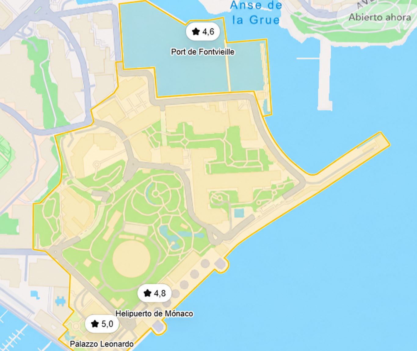
The spatial boundary used by the Monaco Research Observatory organises observations carried out in Fontvieille and its immediate port surroundings.
The perimeter is not intended to reproduce an administrative or institutional boundary. Its function is to provide an operational unit for relating observations of mobility, routes, infrastructure, the waterfront, and urban connections.
03 · Mobility Interface Movement as a Structuring Element
Fontvieille can be analysed as an interface between different forms of mobility. Movement does not take place in a neutral space: it depends on routes, connections, boundaries, changes of direction, and relationships between infrastructure and urban configuration.
The research interest lies in observing how different movements may coexist within the same spatial field without necessarily forming a single circulation system.
↓
PEDESTRIAN MOVEMENT + VEHICLE MOVEMENT + PORT MOBILITY
↓
MOBILITY INTERFACE
04 · Movement Observation Circulation and Spatial Connectivity
The video makes it possible to observe the area as a temporal sequence, recording changes in position, direction, proximity, and relationships among different components of urban space.
Location: Fontvieille · Monaco
Visual source: Monaco Visual Fieldwork Archive (MVFA)
Fieldwork: 2017–2026
Video Fieldwork: © Xavier Reinaldo-Virgili
Description: Audiovisual recording intended to document movement, circulation, and spatial relationships within Fontvieille.
Research use: Urban Mobility · Movement Sequence · Spatial Connectivity · Mobility Interface
05 · Waterfront & Port-City Relations City and Maritime Landscape
The presence of the port introduces a second dimension of mobility. The waterfront establishes a relationship between land-based space, port infrastructure, vessels, and nearby routes.
This proximity makes it possible to study how the maritime landscape enters the urban visual field and how port edges simultaneously organise observation, circulation, and functional differentiation.
Visual continuity between these elements does not imply functional continuity across all observable spaces.
06 · Waterfront Observation Movement and Port Landscape
Location: Fontvieille · Waterfront
Visual source: Monaco Visual Fieldwork Archive (MVFA)
Fieldwork: 2017–2026
Video Fieldwork: © Xavier Reinaldo-Virgili
Description: Audiovisual recording of Fontvieille’s maritime surroundings intended to document the relationship between the waterfront, port infrastructure, movement, and the urban landscape.
Research use: Waterfront Mobility · Port-City Relations · Maritime Landscape · Visual Co-presence
07 · Comparative Reading Layers of the Research Area
| Research Layer | Observed Material | Research Relevance |
|---|---|---|
| Urban Mobility | Pedestrian and vehicle movement | Movement · circulation · route organisation |
| Waterfront | Promenade · urban edge · maritime field | Visual relations · movement · spatial transition |
| Port Infrastructure | Harbour · berths · maritime infrastructure | Port-City Relations · functional differentiation |
| Spatial Connectivity | Approaches · transitions · route changes | Orientation · sequence · connectivity |
| Visual Field | Urban fabric · waterfront · port · movement | Spatial context · simultaneous observation |
08 · Place as Sequence Fontvieille Through Movement
Audiovisual evidence makes it possible to interpret the area not merely as a static urban composition, but as a sequence of relationships that change during movement.
This sequence does not constitute a mandatory itinerary. It merely represents different situations that can be documented during spatial observation of the area.
09 · Research Dimensions Research dimensions
|
Urban Mobility Circulation, movement, direction, and the coexistence of different forms of mobility. |
|
Mobility Interface Relationships between circulation systems, infrastructure, and spatial configuration. |
|
Port-City Relations Spatial and visual relationships between the urban fabric and port infrastructure. |
|
Waterfront Urban edges, routes near the sea, and relationships with the maritime landscape. |
|
Spatial Connectivity Approaches, transitions, changes of direction, and continuity between sectors. |
|
Temporal & Sequential Observation Transformation of the spatial field during movement documented on video. |
10 · Interpretative Limits Limits of the Evidence
Proximity ≠ interaction.
Waterfront visibility ≠ port access.
Co-presence ≠ functional equivalence.
Observed route ≠ habitual route.
Movement sequence ≠ motivation.
Visual evidence ≠ statistical representation.
The evidence makes it possible to record movement, direction, proximity, position, sequence, and spatial relationships. Individual motivations or the purpose of each movement require additional information.
Repeated Fieldwork · 2017–2026
The photograph and two video observations presented on this page come from the Monaco Visual Fieldwork Archive (MVFA), developed through repeated fieldwork in Monaco between 2017 and 2026 by Xavier Reinaldo-Virgili.
The three selected items document spatial context, movement, urban connections, and relationships between the territory, waterfront, and port infrastructure.
The selection serves as contextualised visual evidence. It does not constitute comprehensive coverage of Fontvieille or a statistically representative sample of all movements, users, or configurations in the area.
© Xavier Reinaldo-Virgili · Monaco Visual Fieldwork Archive (MVFA) · 2017–2026
12 · Documentation Archive and Traceability
MVFA — Broader Visual Fieldwork Collection: Scope and Documentation
Open archive documentation →
Monaco Research Observatory · OSF
Public repository →
Fontvieille as a Mobility Interface
The value of Fontvieille as a Research Area lies in the opportunity to examine urban mobility, port infrastructure, the waterfront, and spatial connections together.
The area makes it possible to analyse how different forms of movement share a territory without necessarily sharing the same trajectories, functions, or access conditions.
The photograph provides the overall spatial context, while the two audiovisual observations introduce sequence, direction, and temporal change into the interpretation of the territory.

