Spatial research area devoted to the study of heritage tourism, commercial routes, visual culture, monumental architecture, topography, mobility and forms of tourist observation within Monaco’s historic centre.
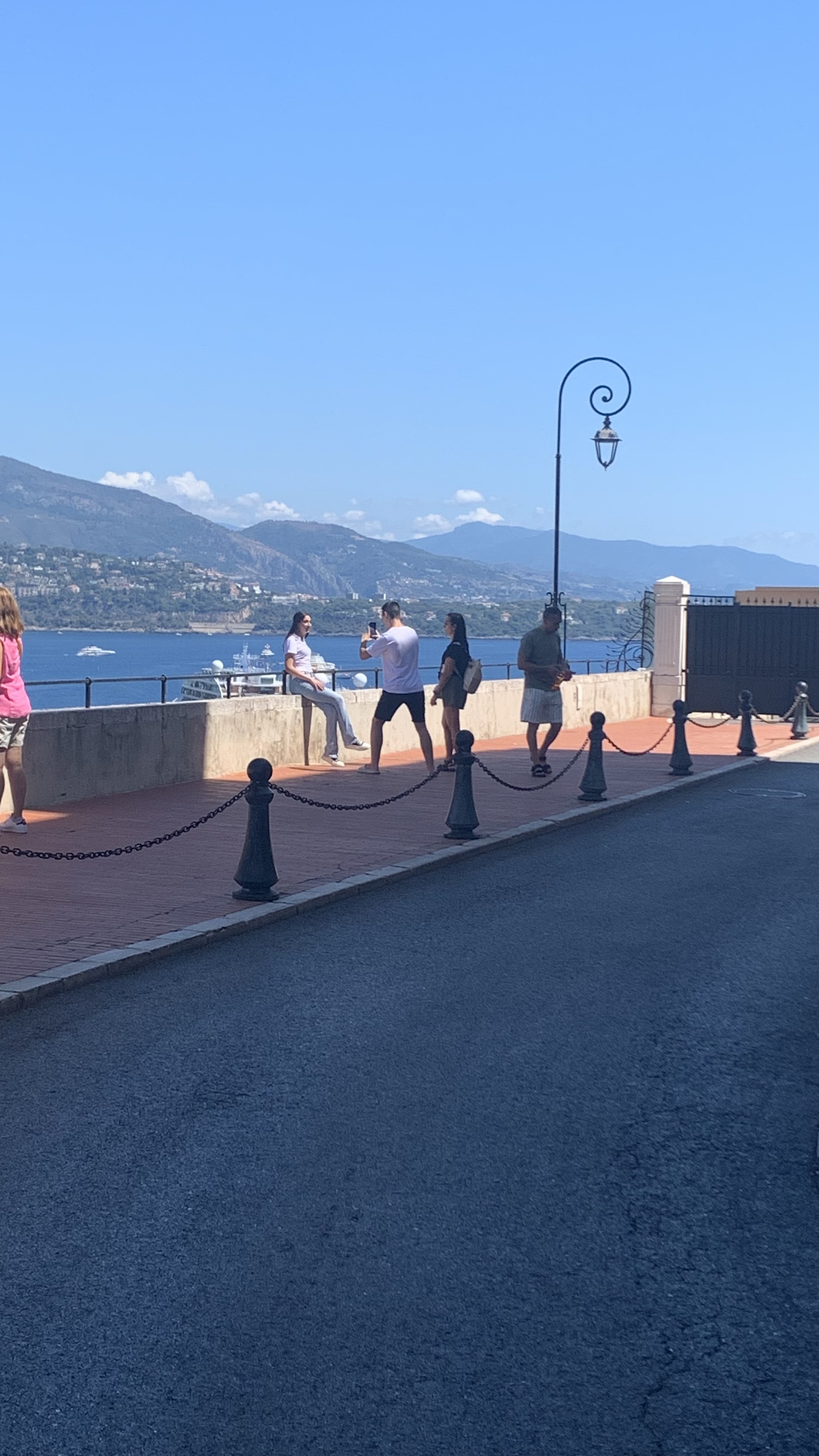
Location: Monaco-Ville / Le Rocher
Visual source: Monaco Visual Fieldwork Archive (MVFA)
Fieldwork: 2017–2026
Photography: © Xavier Reinaldo-Virgili
Description: Elevated tourist observation point offering a panoramic perspective over different parts of Monaco.
Research use: Topography · visual field · tourist observation · urban landscape
Research Area Historic streets, tourism and elevated observation
Monaco-Ville / Le Rocher provides a particularly suitable setting for examining how different dimensions of tourism overlap within a compact historic urban fabric.
Commercial streets, tourism-related businesses, terraces, religious and cultural architecture, territorial symbols, pedestrian routes, access points and elevated viewpoints all form part of a spatial experience shaped by movement through the area.
The visual material presented on this page makes it possible to examine Monaco-Ville not merely as a collection of monuments, but as a tourism landscape in operation: a place where movement, consumption, heritage, mobility, observation and visual representation are interconnected within the same territory.
01 · Research Area Profile Research context
| Research Area | Monaco-Ville / Le Rocher |
|---|---|
| Area Code | RO |
| Fieldwork Period | 2017–2026 |
| Evidence | 7 Photographs · 5 Video Observations · Spatial Observation |
| Primary Research Themes | Heritage Tourism · Commercial Streetscape · Tourist Observation · Visual Iconography · Topography · Pedestrian Circulation · Tourism Mobility · Monumental Architecture |
| Visual Archive | Monaco Visual Fieldwork Archive (MVFA) · 2017–2026 |
02 · Research Perimeter Spatial scope
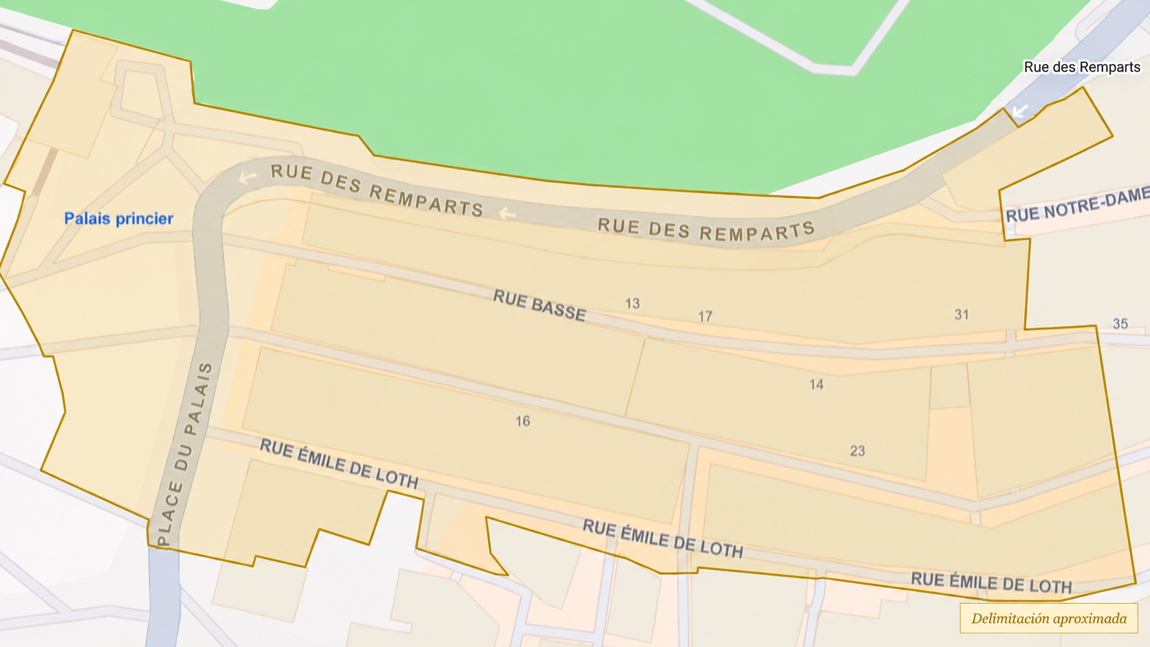
The perimeter used by the Monaco Research Observatory provides a territorial framework for organising fieldwork conducted in Monaco-Ville / Le Rocher. It is not intended to replace any official administrative boundary.
Within this framework, commercial streets, heritage spaces, routes, access points, observation points, monumental architecture and different mobility interfaces can be examined in relation to one another.
03 · Topography & Approach Reaching and observing Le Rocher
Monaco-Ville’s elevated position establishes a direct relationship between movement, changes in elevation and the visual field. Reaching particular panoramic viewpoints is not merely a destination in itself: the journey also makes it possible to document gradual changes in altitude, orientation and what becomes visible.
Location: Monaco-Ville / Le Rocher
Visual source: Monaco Visual Fieldwork Archive (MVFA)
Fieldwork: 2017–2026
Video Fieldwork: © Xavier Reinaldo-Virgili
Description: Route towards a panoramic viewpoint that documents changes in elevation and the relationship between movement, altitude and the progressive opening of the visual field.
Research use: Topography · spatial sequence · observation · change in elevation
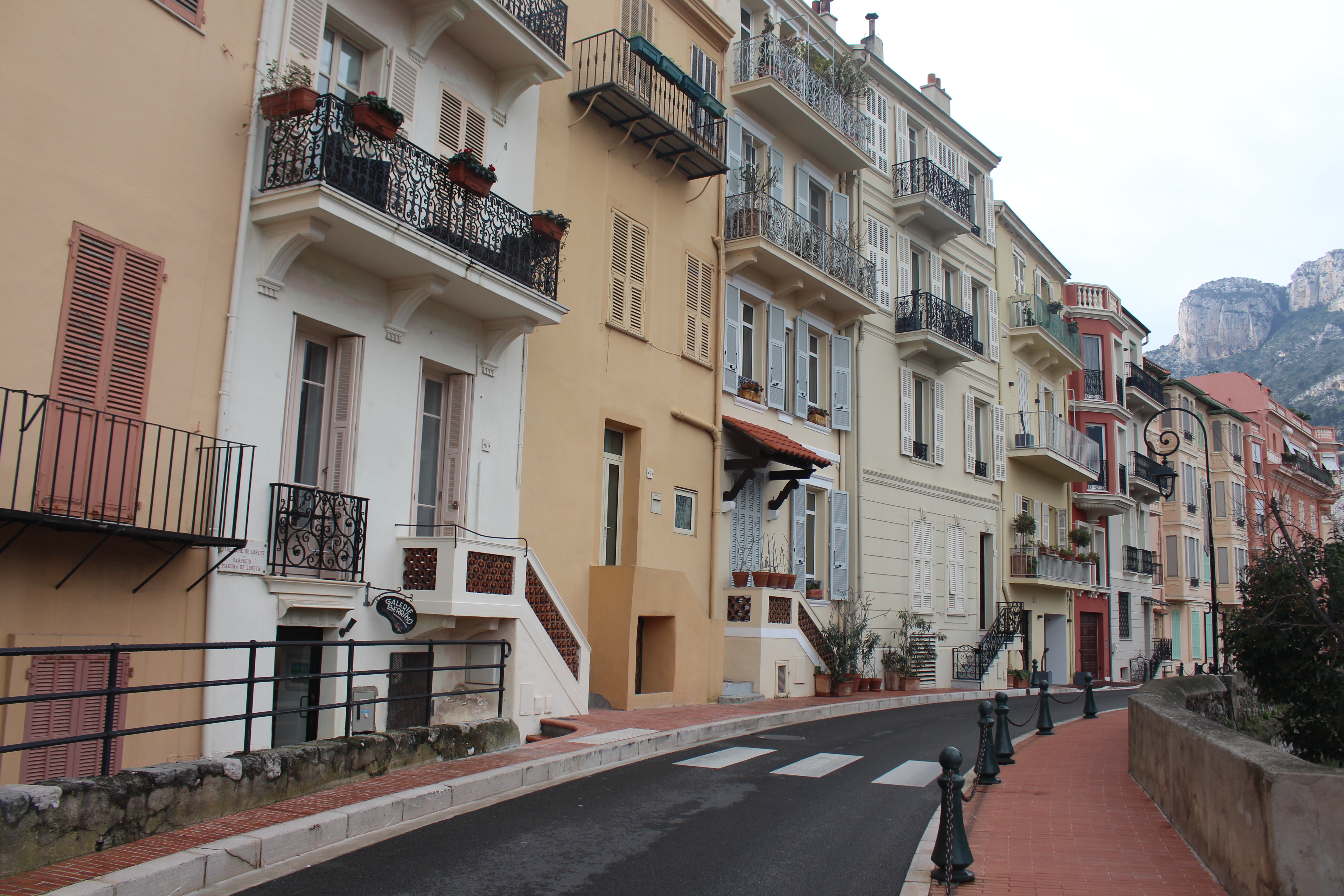
Location: Rue des Remparts · Monaco-Ville
Visual source: Monaco Visual Fieldwork Archive (MVFA)
Fieldwork: 2017–2026
Photography: © Xavier Reinaldo-Virgili
Description: Access point to Monaco-Ville’s urban fabric from Rue des Remparts, documenting the transition between the approach route, entry into the historic area and pedestrian continuity.
Research use: Access · spatial transition · route · orientation
Location: Place d’Armes · approach area to Le Rocher
Visual source: Monaco Visual Fieldwork Archive (MVFA)
Fieldwork: 2017–2026
Video Fieldwork: © Xavier Reinaldo-Virgili
Description: A tourist bus passing through Place d’Armes, documenting a form of tourist mobility associated with approach routes to the historic centre.
Research use: Tourist mobility · approach interface · transport · spatial sequence
Topography shapes particular possibilities for movement and observation, but an elevated position does not, in itself, determine the visitor’s experience or interpretation.
04 · Commercial Tourist Streetscape Walking, consumption and the historic street
Tourism activity in Monaco-Ville is not limited to visiting monuments. A significant part of the experience takes place along commercial streets, among small businesses, on terraces and along pedestrian routes integrated into the historic urban fabric.
The narrow scale of many streets brings pedestrian circulation, shopfronts, hospitality venues and places to stop into close proximity, creating a landscape in which tourist consumption and urban experience are spatially intertwined.
Location: Monaco-Ville
Visual source: Monaco Visual Fieldwork Archive (MVFA)
Fieldwork: 2017–2026
Video Fieldwork: © Xavier Reinaldo-Virgili
Description: A walk along one of Monaco-Ville’s main commercial and tourist streets, documenting the continuity between pedestrian movement, shop windows, commercial activity and the experience of the historic quarter.
Research use: Commercial tourism · pedestrian circulation · street experience · historic fabric
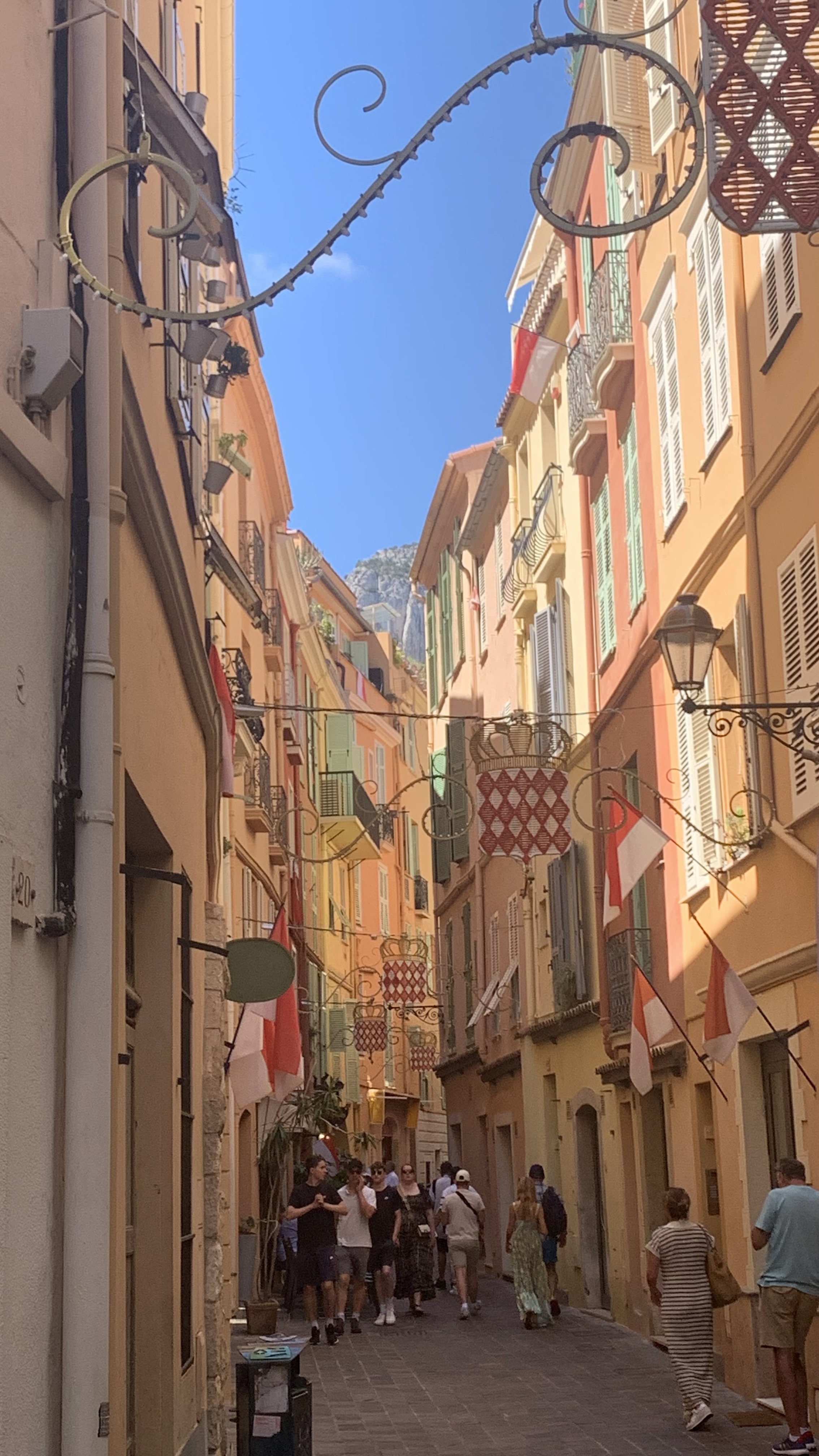
Location: Monaco-Ville
Visual source: Monaco Visual Fieldwork Archive (MVFA)
Fieldwork: 2017–2026
Photography: © Xavier Reinaldo-Virgili
Description: View of one of the main commercial and tourist streets in the historic quarter, where pedestrian circulation and commercial activity share the same linear space.
Research use: Tourism commerce · pedestrian street · urban morphology · visitor experience
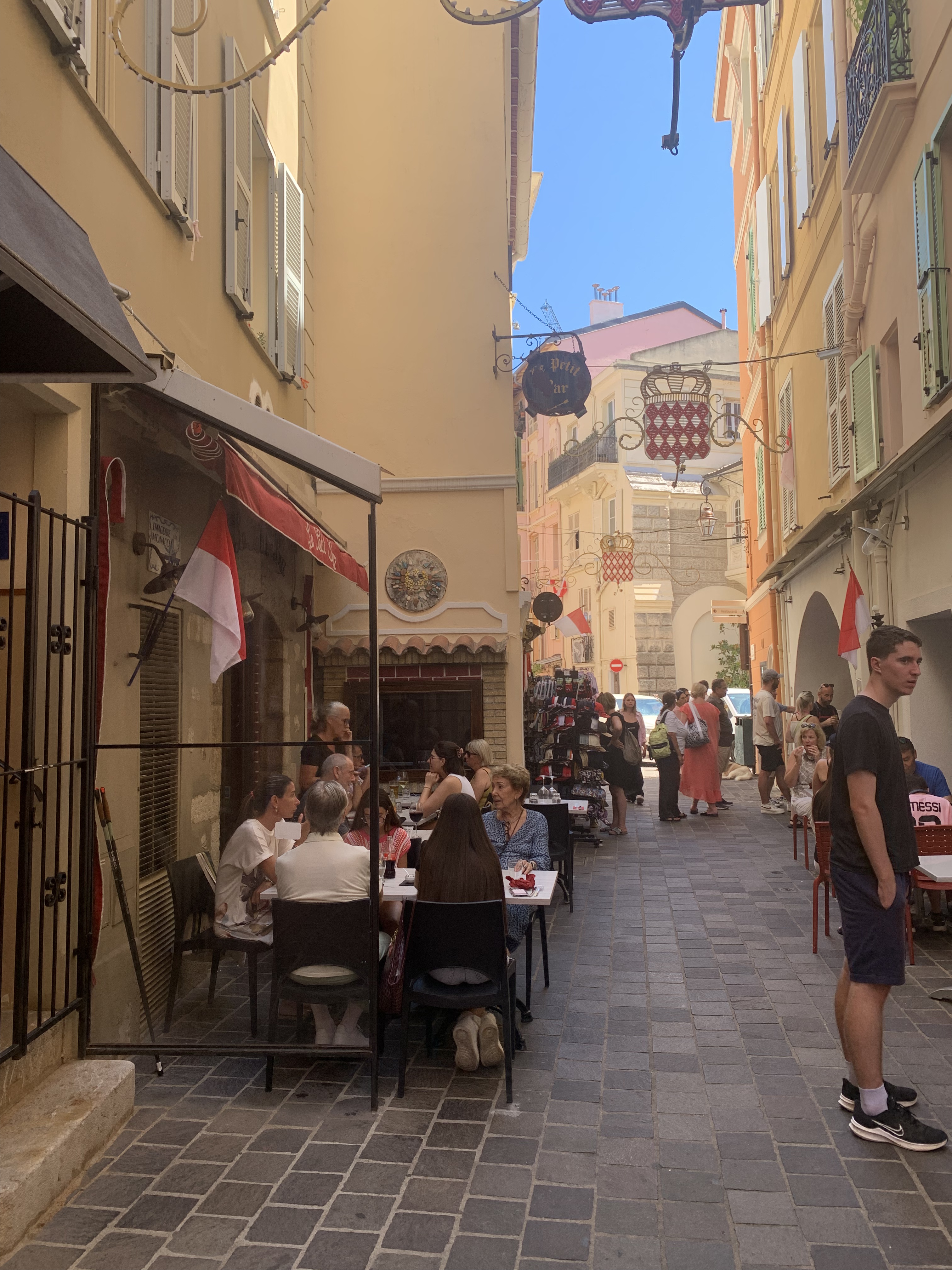
Location: Monaco-Ville
Visual source: Monaco Visual Fieldwork Archive (MVFA)
Fieldwork: 2017–2026
Photography: © Xavier Reinaldo-Virgili
Description: People occupying a terrace within one of the historic quarter’s narrow streets. The scene shows the overlap between movement, lingering, hospitality activity and compact urban fabric.
Research use: Hospitality · public-space interface · permanence · tourist street life
Location: Monaco-Ville
Visual source: Monaco Visual Fieldwork Archive (MVFA)
Fieldwork: 2017–2026
Video Fieldwork: © Xavier Reinaldo-Virgili
Description: An interior recording of La Maison du Limoncello, adding the commercial and gastronomic dimension of the tourist route through the historic quarter to the area’s documentation.
Research use: Tourism commerce · local products · interior retail environment · visitor economy
Location: Place de la Visitation · Monaco-Ville
Visual source: Monaco Visual Fieldwork Archive (MVFA)
Fieldwork: 2017–2026
Video Fieldwork: © Xavier Reinaldo-Virgili
Description: A sequence showing the approach to and entry into Chocolaterie de Monaco, documenting how an established commercial venue fits within the pedestrian and tourist route through Le Rocher.
Research use: Commercial access · tourist consumption · route sequence · historic commercial landscape
Commercial activity forms part of the observable tourism landscape, but the visibility of a business does not establish the purchasing behaviour of individual visitors.
05 · Visual Identity & Iconography Symbols within the historic streetscape
The visual identity of the area does not depend solely on its monumental buildings. Decorative elements, coats of arms, flags, signs, materials and other symbols are integrated into streets and façades, introducing recognisable territorial references along everyday routes.
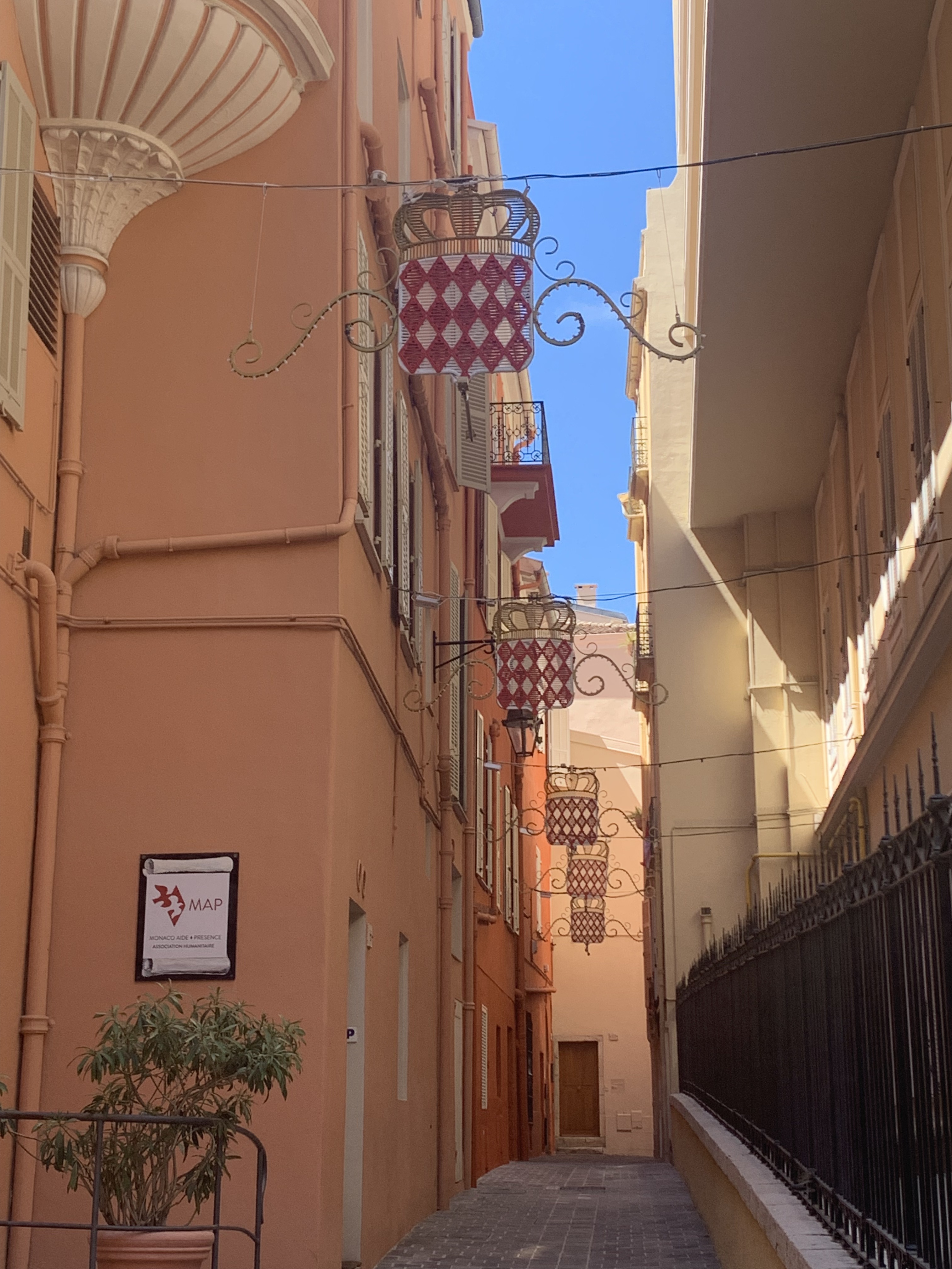
Location: Monaco-Ville
Visual source: Monaco Visual Fieldwork Archive (MVFA)
Fieldwork: 2017–2026
Photography: © Xavier Reinaldo-Virgili
Description: Coats of arms of Monaco suspended above a street in the historic quarter, integrating territorial symbols into the visual experience of the urban route.
Research use: Visual iconography · territorial identity · symbolism · historic streetscape
06 · Monumental Heritage Architecture within the tourist field
Alongside its commercial and residential fabric, Monaco-Ville contains monumental buildings whose scale, materials and architectural languages are clearly differentiated from their immediate surroundings.
Visual research makes it possible to study not only each monument as an individual object, but also its relationship with streets, tourist routes, open spaces and the positions from which it can be observed.
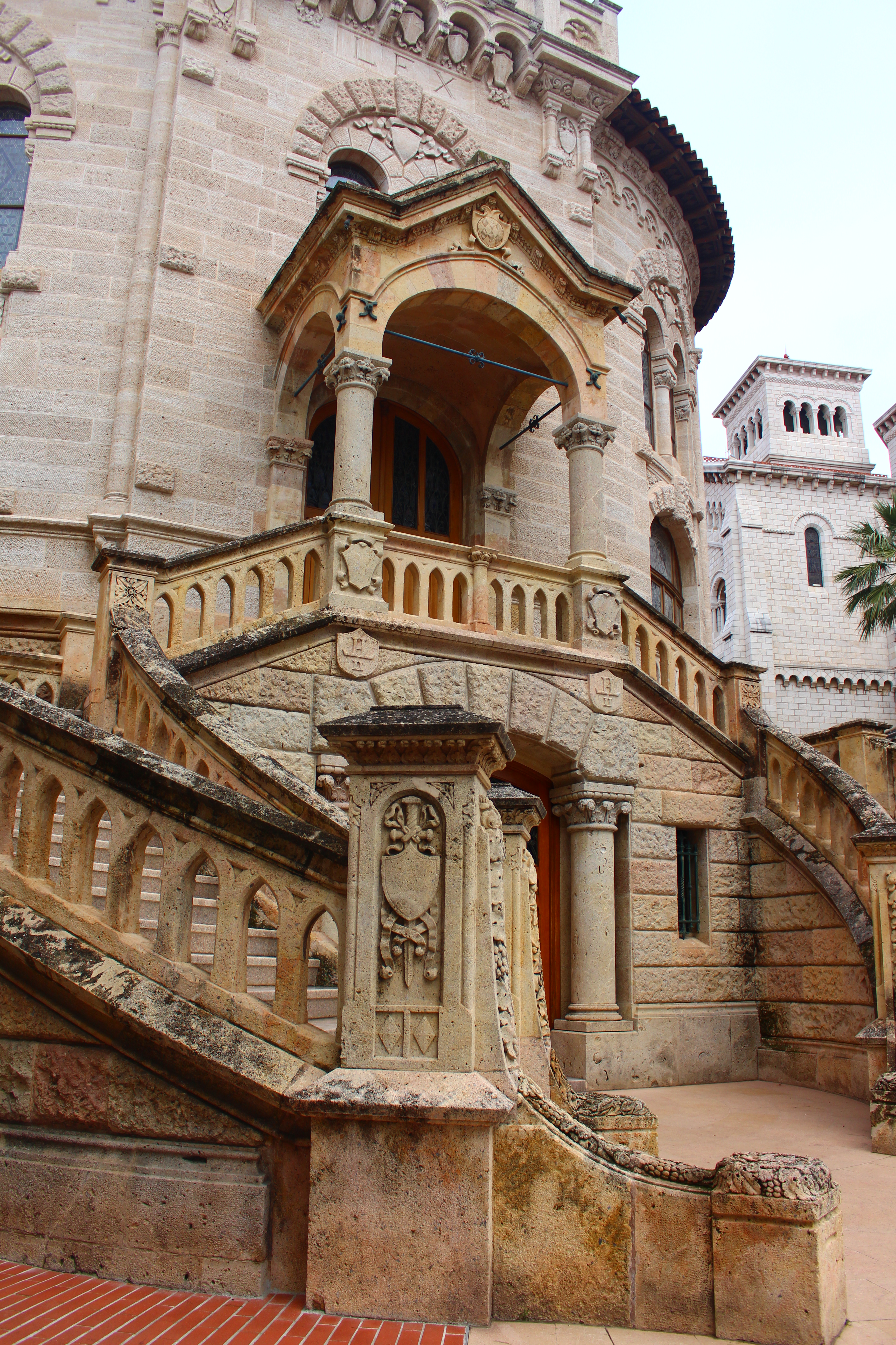
Location: Monaco-Ville / Le Rocher
Visual source: Monaco Visual Fieldwork Archive (MVFA)
Fieldwork: 2017–2026
Photography: © Xavier Reinaldo-Virgili
Description: Side view of the Cathédrale Notre-Dame-Immaculée, a building with a Neo-Romanesque architectural language and Byzantine influences, forming part of the monumental and institutional landscape of Le Rocher.
Research use: Religious architecture · heritage · monumental landscape · visual tourism
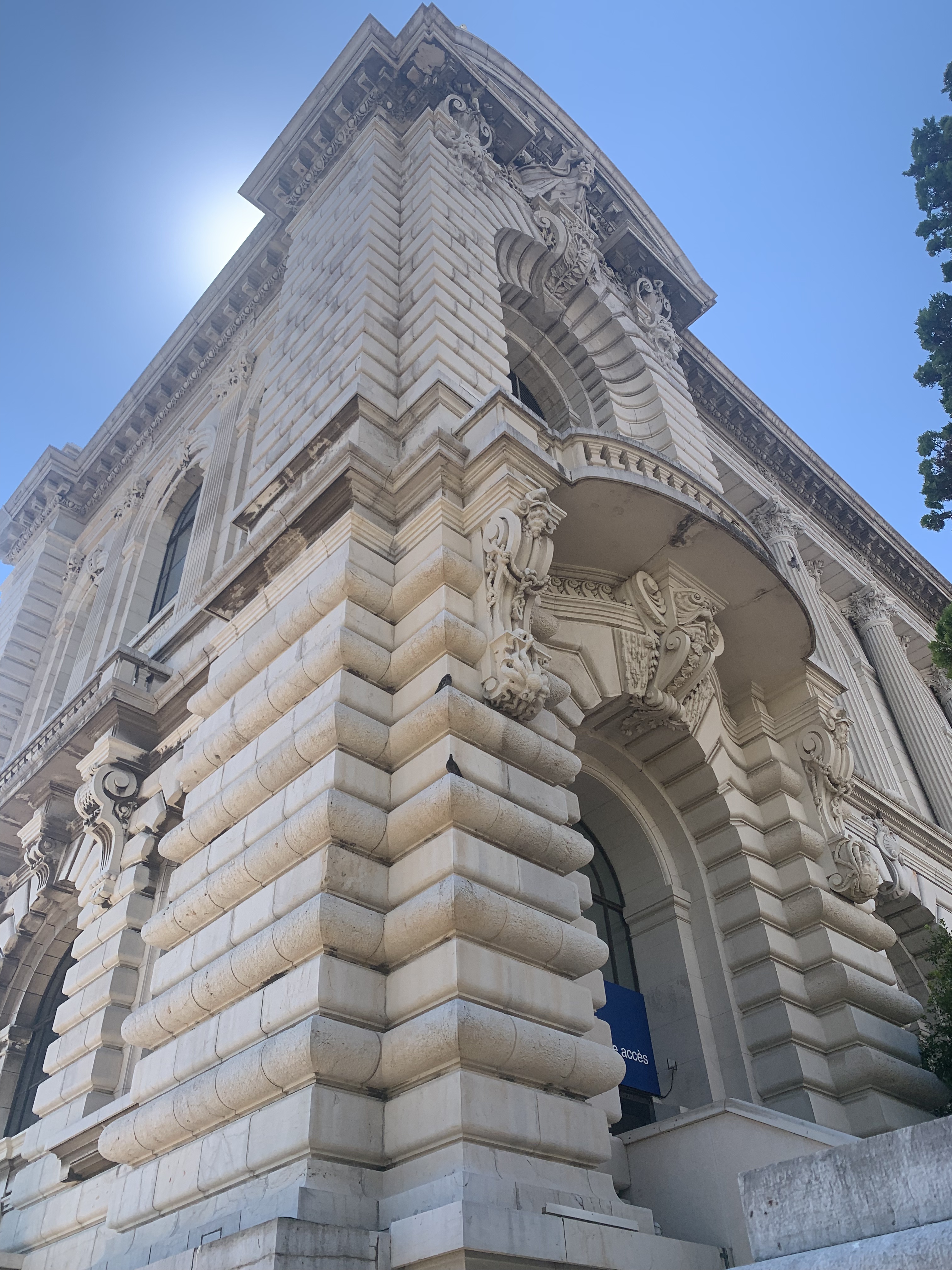
Location: Monaco-Ville / Le Rocher
Visual source: Monaco Visual Fieldwork Archive (MVFA)
Fieldwork: 2017–2026
Photography: © Xavier Reinaldo-Virgili
Description: Side view of the Musée Océanographique, where the building’s monumental scale, position on Le Rocher and richly articulated architecture give it a dominant presence within the tourist landscape.
Research use: Monumental architecture · cultural tourism · heritage landscape · visual prominence
07 · Comparative Reading Different layers of the tourist landscape
The collection of recordings shows that Monaco-Ville can be analysed as the overlap of several spatial and visual layers.
| Research Layer | Observed Material | Tourism Relevance |
|---|---|---|
| Topography | Changes in elevation, elevated routes and panoramic views | Observation · orientation · landscape experience |
| Commercial Streetscape | Commercial streets, shops, hospitality venues and terraces | Consumption · walking · stopping · visitor economy |
| Visual Iconography | Coats of arms and symbolic elements integrated into the urban environment | Destination identity · visual recognition · symbolic landscape |
| Monumental Heritage | Cathedral · Musée Océanographique · historic architecture | Heritage tourism · observation · destination imagery |
| Pedestrian Experience | Narrow streets, approaches, access points and linear sequences | Movement · route experience · orientation |
| Tourism Mobility | Tourist bus and approach areas | Access · circulation · connection with the historic area |
08 · Tourism in the Visual Field Observed visitor-space relations
The audiovisual material allows the area to be examined beyond its individual monuments. Tourism is also visible in movement, entry into establishments, the use of terraces, travel by tourist transport and visits to panoramic viewpoints.
These observations make it possible to document how different tourism functions are distributed across the territory without assuming that everyone present shares the same motivation or experiences the space in the same way.
Commercial presence ≠ demonstrated consumption.
Spatial position ≠ subjective experience.
Tourist infrastructure ≠ demonstrated tourist status.
09 · Place as Sequence From access to observation
One of the main contributions of the audiovisual material is to show Monaco-Ville as a sequential experience. The area can be documented through transitions between approach, access, walking, commercial activity, heritage and panoramic observation.
This sequence is not a prescribed itinerary. It is a tool for understanding how different components of the tourism landscape may appear successively while moving through Le Rocher.
Repeated Fieldwork · 2017–2026
The photographs and video observations presented on this page come from the Monaco Visual Fieldwork Archive (MVFA), developed through repeated fieldwork in Monaco between 2017 and 2026 by Xavier Reinaldo-Virgili.
The twelve selected items document topography, observation points, access points, tourist mobility, commerce, hospitality, visual iconography and monumental architecture.
Their inclusion provides contextualised visual evidence and is not intended to constitute exhaustive coverage of Monaco-Ville / Le Rocher or a statistically representative sample of tourism activity in the area.
© Xavier Reinaldo-Virgili · Monaco Visual Fieldwork Archive (MVFA) · 2017–2026
11 · Research Dimensions A multi-layered historic tourism environment
|
Heritage Tourism Relationships between monumental heritage, historic streets and the tourist experience. |
|
Commercial Tourism Commercial streets, specialist shops, hospitality venues and consumption along the route. |
|
Visual Culture & Iconography Symbols, coats of arms and visual elements associated with representations of Monaco. |
|
Pedestrian Circulation Access points, narrow streets, commercial thoroughfares, orientation and sequences of movement. |
|
Topography & Observation Changes in elevation, elevated positions, panoramic views and the opening of the visual field. |
|
Monumental Architecture Religious, cultural and institutional architecture integrated into the tourist landscape. |
|
Tourism Mobility Tourist transport, approach interfaces and the relationship between mobility and territory. |
|
Spatial Experience Relationships between movement, lingering, consumption, observation and landscape. |
12 · Research Connections Related research
|
Visual Research
Monaco Visual ObservatoryTourist Observation · Visual Behaviour · Urban Space |
Visual Iconography
Visual Iconography of MonacoHeraldry · Symbols · Architecture · Destination Identity |
|
Spatial Research
Monaco Spatial & Visual AtlasResearch Areas · Routes · Observation Points |
Visual Archive
Monaco Visual Fieldwork ArchivePhotography · Video · Provenance · Repeated Fieldwork |
Research Interpretation Monaco-Ville / Le Rocher as a tourism research area
The audiovisual collection presents Monaco-Ville / Le Rocher as a territory in which heritage and tourism cannot be understood solely through its monumental buildings.
The experience of the area also unfolds along commercial streets, on terraces, in specialist establishments, at access points, on tourist transport and through the gradual opening of panoramic perspectives associated with the topography of Le Rocher.
By combining photography and video, the Research Area can document both relatively stable spatial configurations and sequences of movement, approach, entry, walking, observation and commercial activity.

