Monaco Spatial & Visual Atlas · Research Area
1 Spatial Case · 3 Visual Assets · Final Empirical Release
Historic urban circulation, longitudinal visibility and route structure along Rue des Remparts.
This territorial profile examines Rue des Remparts as a delimited urban route within Monaco-Ville. The case makes it possible to examine visual continuity, route legibility, pedestrian accessibility and the channelling of movement together.
The published evidence relates exclusively to VAM-MC-128 and must not be extrapolated to Monaco-Ville or Le Rocher as a whole.
Spatial Profile
Historic Urban Route as a Spatial Unit
Unlike Place du Casino or Port Hercule, the unit examined in Le Rocher is neither a square, an institutional complex nor a harbour interface. Rue des Remparts functions primarily as a linear sequence of pedestrian circulation.
The analysis considers continuity along the axis, the legibility of its edges, longitudinal orientation, opportunities for observation and circulation conditions throughout the route.
This unit introduces a different configuration into the Atlas: rather than a single destination, it is a urban route treated as one Spatial Case, avoiding the artificial subdivision of the same route into multiple micro-cases.
Area Overview
Empirical Base
Spatial Unit
VAM-MC-128 · Rue des Remparts
The unit covers Rue des Remparts and its immediately adjacent functional edge. The corpus combines a longitudinal perspective, a lateral view and a continuous audiovisual record of movement along the route.
Case ID: VAM-MC-128
Spatial Type: Urban Route / Transition
Pattern: Axis
Zone: Le Rocher
Spatial Scope: Rue des Remparts route
VAM Configuration: Publicly Permeable Luxury
SECP Result: Confirmed SE2 · Route Steering and Circulation Control
VAM Area Profile
Final Visibility and Accessibility Profile
VAM-MC-128 has final scores for all ten dimensions. The case is therefore presented not merely in terms of documentary coverage but through its final empirical profile.
Visibility Score
High
Accessibility Score
Very high
Visibility Dimensions · 0–4
External Visual Exposure
Sightline Continuity
Interior & Activity Legibility
Display Intensity
Observation Opportunity
Accessibility Dimensions · 0–4
Physical Accessibility
Economic Accessibility
Social Accessibility
Temporal Accessibility
Normative Accessibility
SECP Area Profile
Reviewed Opportunity Structure
Because the area contains just one case, Rue des Remparts generates 12 Case × Category combinations. Only SE2 has a YES assessment opportunity in the final record.
Evidence Rule
Linear Geometry ≠ Automatic Route Steering
The mere existence of a linear street is not sufficient to confirm SE2 · Route Steering and Circulation Control. A historic route may naturally organise movement as a consequence of its morphology.
For VAM-MC-128, the longitudinal photograph and continuous audiovisual record provided specific evidence for assessing continuity, direction, points of friction and movement channelling along the route. Following empirical review, SE2 was confirmed for the defined scope.
The confirmation describes an observable effect of route steering. It does not in itself establish discriminatory intent, an intention to exclude or pedestrians’ subjective experience.
Observable Spatial Mechanisms
How the Route Operates Spatially
Longitudinal Visibility
The linear configuration provides an extended view of spatial continuity along the route.
Route Legibility
The axis makes the overall continuity of pedestrian movement easy to recognise.
Spatial Edges
The lateral edges structure the route and constrain immediate alternatives for movement.
Route Steering
The longitudinal and dynamic evidence supported confirmation of observable movement channelling within the area studied.
Public Accessibility
The route provides broad conditions of access, free use and legitimate public use.
Observation Opportunity
The sequence provides several vantage points from which the continuity and structure of the axis can be observed.
Complete Territorial Case Set
VAM-MC-128
Monaco-Ville · Rue des Remparts
Visibility Score: 75 · High
Accessibility Score: 90 · Very high
Matrix Configuration:
Publicly Permeable Luxury
Confirmed SECP:
SE2 · Route Steering and Circulation Control
The longitudinal and lateral views make the route and its edges clearly identifiable. Access remains free and broadly open to public use, while the configuration of the axis produces an observable effect of movement channelling.
Selected Photographic Evidence
Complete Static Evidence Set
The corpus contains two photographs. The first directly supports the evidence for SE2; the second provides spatial context for the case.
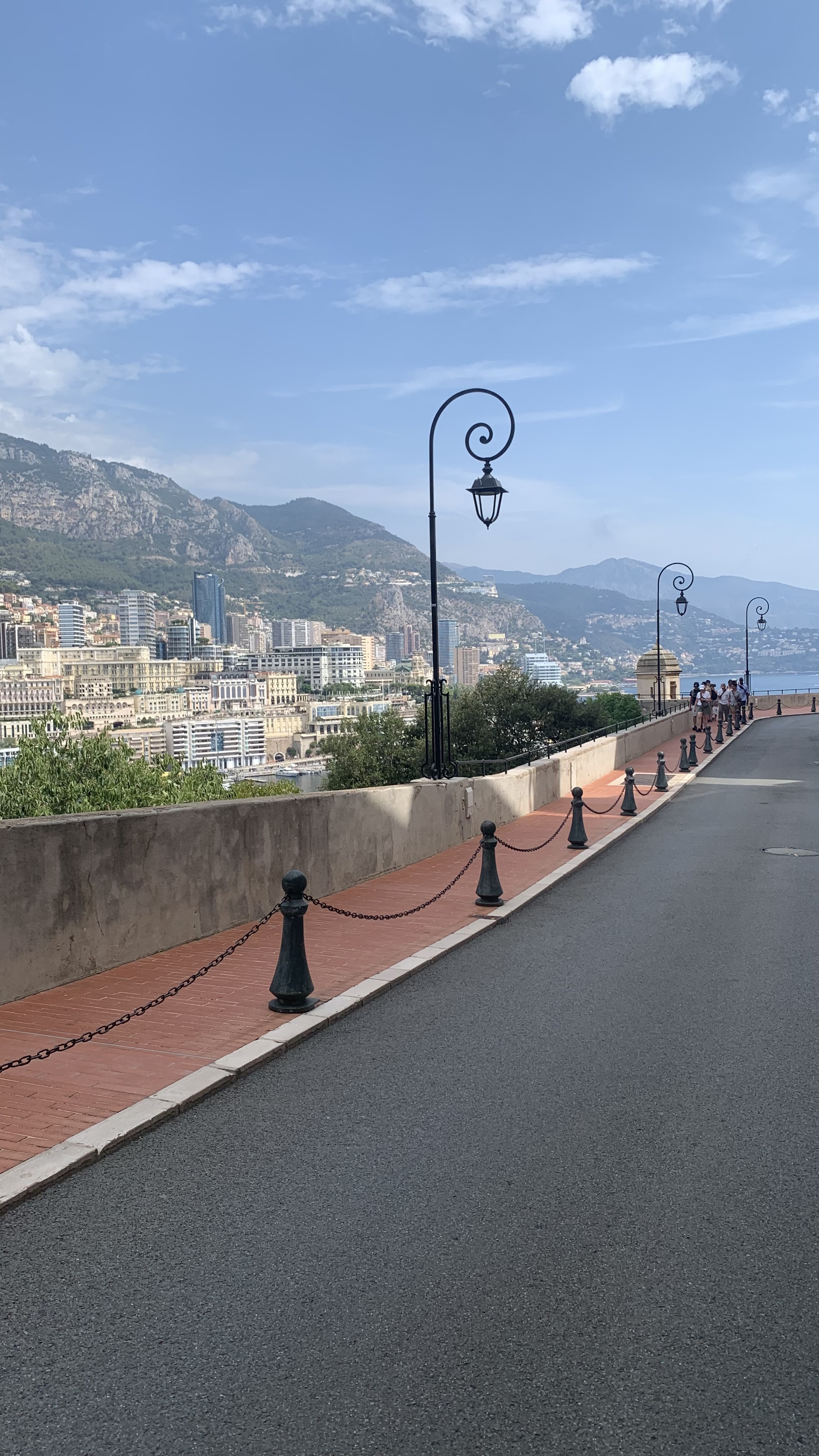
Monaco-Ville — longitudinal view of Rue des Remparts.
Evidence: Photograph · APR
VAM Dimensions: V1 · V2 · V5 · A1
SECP Status: Supporting evidence for Confirmed SE2.
The asset documents the longitudinal approach, continuity of the axis and observable points of friction along the route.
© Xavier Reinaldo-Virgili · Monaco Visual Fieldwork Archive
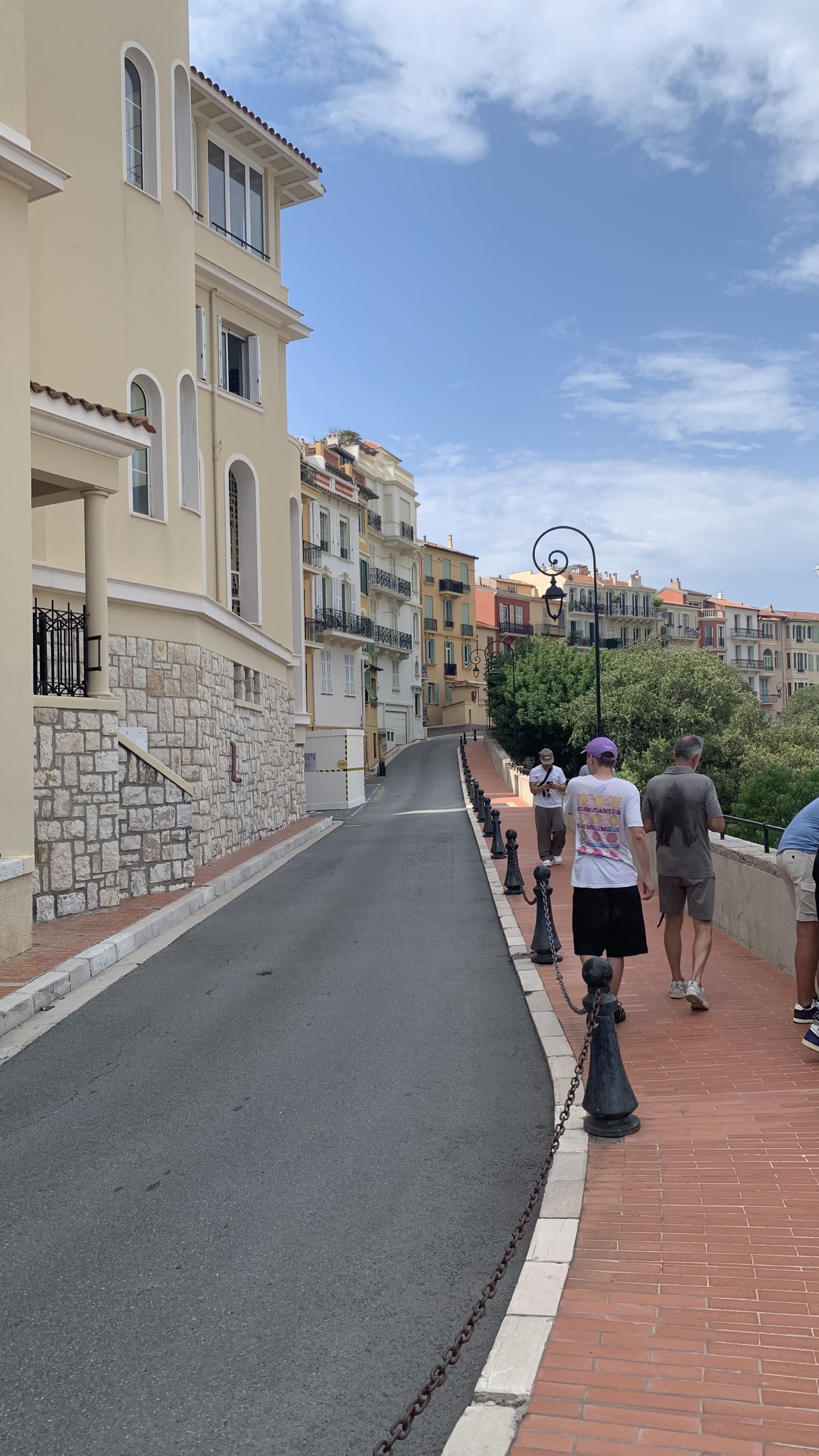
Monaco-Ville — lateral view of the route and its edges.
Evidence: Photograph · CTX
VAM Dimensions: V1 · V2 · V5
SECP Status: Supporting Context · No SECP Target.
The photograph contextualises the edges and visual relationships of the setting without constituting an independent SECP occurrence.
© Xavier Reinaldo-Virgili · Monaco Visual Fieldwork Archive
Traceability. The photographs retain their final Asset IDs. The distinction between diagnostic evidence and contextual material is maintained to avoid treating every representation of urban form as an SECP occurrence.
Selected Video Evidence
Traceable Dynamic Evidence
The audiovisual record continuously documents progression along Rue des Remparts. The temporal sequence makes it possible to assess continuity, alternative movements and the channelling of trajectories more precisely than a single photograph can.
Dynamic Evidence 01
Rue des Remparts — Continuous Route Sequence
MVFA-V-2026-RO-0128 · VAM-MC-128 · APR
Original File: IMG_9099
VAM Dimensions: V1 · V2 · V5 · A1
SECP Status:
Supporting evidence for Confirmed SE2.
The sequence dynamically documents the approach and movement along Rue des Remparts. Together with the longitudinal photographic evidence, it allowed deviations, continuity and controls to be assessed and supports the final confirmation of SE2 · Route Steering and Circulation Control.
Audiovisual Evidence Note. The video is played directly from the WordPress media library and retains the same Asset ID used in the master inventory.
Fieldwork Route
Rue des Remparts Sequence
The route remains a single functional sequence. The different photographic viewpoints and the video do not generate separate cases; instead, they provide complementary evidence for VAM-MC-128.
Comparative Interpretation
High Accessibility Can Coexist with Route Steering
VAM-MC-128 has a configuration with Visibility 75 and Accessibility 90. The route is widely accessible and falls within Publicly Permeable Luxury.
The confirmation of SE2 does not contradict this high level of accessibility. VAM and SECP address different questions: VAM describes overall conditions of visibility and access, whereas SECP identifies specific spatial mechanisms within the same environment.
Rue des Remparts thus shows that a route can remain open, free of charge and legitimate for public use while also displaying a configuration that observably channels pedestrian movement.
Interpretative Limit: the confirmation of Route Steering and Circulation Control describes observed spatial functioning. It does not establish discriminatory intent or justify generalising the result to Monaco-Ville as a whole.
Research Connections
Data, Methods and Evidence
Empirical Case Profiles
Scores and traceable evidence for selected spatial cases.
MVFA–VAM Evidence & Code Guide
Guide to Asset ID, Case ID, Evidence Code and VAM dimensions.
SECP Empirical Validation
Empirical validation and rules for interpreting the protocol.
Monte Carlo Research Lab
General framework of the Observatory’s research instruments and lines of enquiry.
Monaco Spatial & Visual Atlas
Atlas Home · Place du Casino & Carré d’Or · Port Hercule · Yacht Club de Monaco · Larvotto · Fontvieille

