ES EN
Spatial research area dedicated to studying the relationships between harbour and city, tourism, yachting, mobility, observation, public space and the visibility of Monaco’s nautical landscape.
Waterfront Tourism · Yachting · Port-City Relations · Tourist Observation · Public Space · Marine Mobility · Luxury Visibility
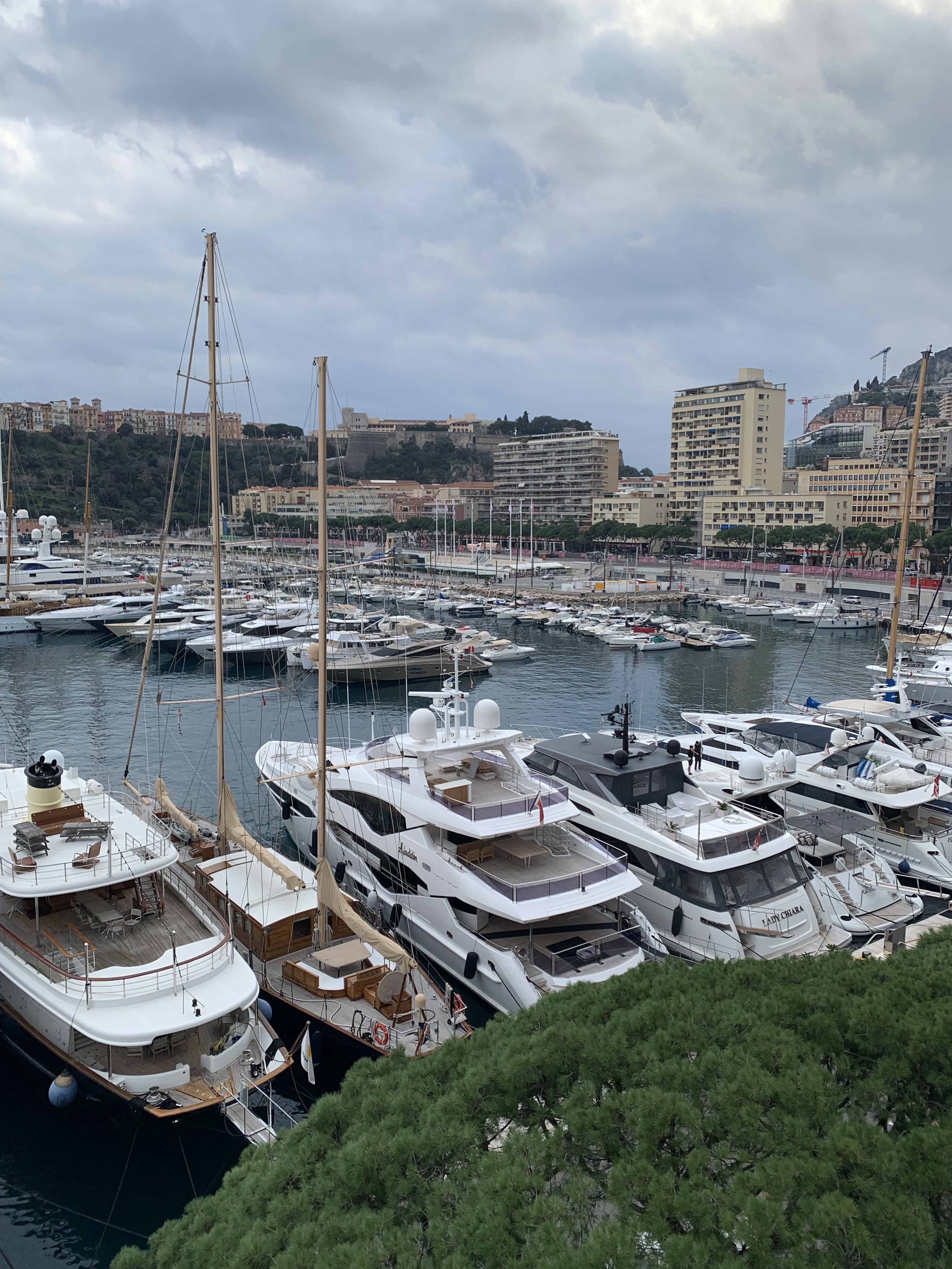
Location: Port Hercule · Monaco
Visual source: Monaco Visual Fieldwork Archive (MVFA)
Fieldwork: 2017–2026
Photography: © Xavier Reinaldo-Virgili
Description: Panoramic view of Port Hercule showing the harbour basin, moorings, vessels, waterfront and surrounding urban fabric within the same scene.
Research use: Port-City Relations · Waterfront Landscape · Spatial Context · Yachting Visibility
Research Area A waterfront between harbour, city and tourist observation
Port Hercule is one of the main observation areas of the Monaco Research Observatory for examining how harbour infrastructure can simultaneously function as a working space, an urban landscape and a setting for the tourist experience.
Its analytical significance lies not only in the presence of yachts. Pedestrian promenades, quays, pontoons, moorings, approach points, urban routes and observation positions create different ways for people to engage with the waterfront.
The new audiovisual corpus is particularly suited to documenting proximity, routes and the visual field: how perceptions of the harbour change when moving horizontally, approaching yachts, walking alongside them or viewing Port Hercule from broader vantage points.
01 · Research Area Profile Research context
| Research Area | Port Hercule |
|---|---|
| Area code | PH |
| Fieldwork period | 2017–2026 |
| Material presented | 1 photograph · 7 video observations |
| Primary research themes | Waterfront Tourism · Yachting · Tourist Observation · Port-City Relations · Public Space · Marine Mobility · Luxury Visibility |
| Visual archive | Monaco Visual Fieldwork Archive (MVFA) · 2017–2026 |
02 · Research Perimeter Spatial scope
Port Hercule is used as a territorial research unit to bring together observations made from different sectors, quays, pedestrian routes and points of approach to the water.
The area makes it possible to examine the harbour basin, its pedestrian edges and its visual connections with the surrounding urban fabric as a whole. The research perimeter is not intended to replace administrative, harbour or institutional boundaries.
The harbour is studied as a spatial system connected to the city, rather than simply as an expanse of water and moorings.
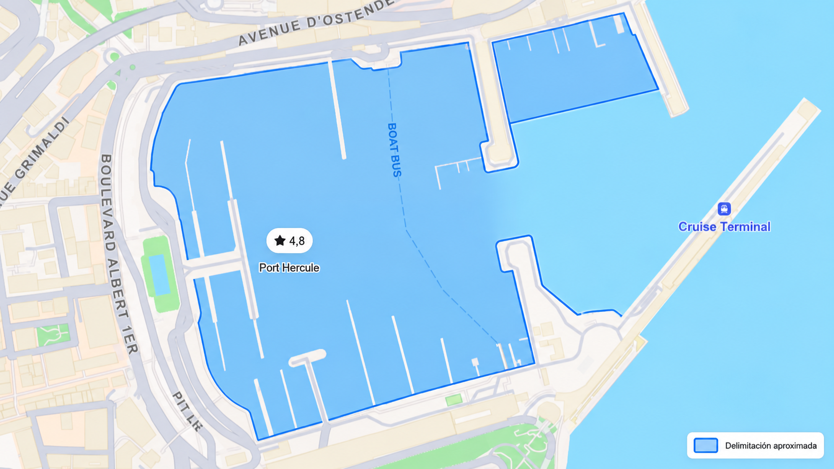
Visual delimitation of the area used to organise fieldwork at Port Hercule and to connect observations made from the waterfront, quays, pedestrian routes and nearby harbour sectors. The perimeter serves exclusively as a research framework and does not represent an official administrative, harbour or institutional boundary.
03 · Harbour and City Port Hercule within the urban landscape
Port Hercule’s configuration makes it possible to view the harbour and much of its urban setting simultaneously. Buildings, roads, slopes, quays and vessels are brought together within the same visual field.
This relationship is particularly useful for examining Port Hercule as a port–city interface: a space where nautical infrastructure, urban landscape and tourist experience are not isolated from one another.
Location: Port Hercule · Monaco
Visual source: Monaco Visual Fieldwork Archive (MVFA)
Fieldwork: 2017–2026
Video Fieldwork: © Xavier Reinaldo-Virgili
Description: Panoramic recording showing the harbour, vessels and surrounding urban fabric, making the spatial relationship between waterfront and city visible.
Research use: Port-City Relations · Panoramic Observation · Waterfront Landscape · Urban Interface
Location: Port Hercule · Monaco
Visual source: Monaco Visual Fieldwork Archive (MVFA)
Fieldwork: 2017–2026
Video Fieldwork: © Xavier Reinaldo-Virgili
Description: Horizontal movement successively documenting different harbour sectors and showing how the visual field changes along the waterfront route.
Research use: Waterfront Sequence · Spatial Movement · Changing Visual Field · Port Observation
The harbour is not experienced solely from a fixed position: movement continually changes the visual relationship between vessels, waterfront and urban fabric.
04 · Harbour Infrastructure and Pontoons The material structure of the harbour
Pontoons, moorings and access structures form part of Port Hercule’s observable landscape, while also highlighting its role as working infrastructure.
Numerous components of the harbour system can be observed from public space without that visibility necessarily implying physical access to them.
Location: Yacht Club de Monaco · Quai Louis II · Port Hercule
Visual source: Monaco Visual Fieldwork Archive (MVFA)
Fieldwork: 2017–2026
Video Fieldwork: © Xavier Reinaldo-Virgili
Description: View from the Yacht Club de Monaco sector on Quai Louis II towards the pontoons and moorings of Port Hercule’s outer harbour. The recording shows the relationship between berthing facilities, vessels and the harbour edge.
Research use: Marina Infrastructure · Berthing Landscape · Quai Louis II · Port Spatial Organisation
Location: Port Hercule · Monaco
Visual source: Monaco Visual Fieldwork Archive (MVFA)
Fieldwork: 2017–2026
Video Fieldwork: © Xavier Reinaldo-Virgili
Description: Close-up view of a pontoon and the physical organisation of a berthing area, showing functional elements that structure the relationship between land, water and vessels.
Research use: Pontoon Infrastructure · Berthing Space · Material Landscape · Waterfront Function
Harbour infrastructure and vessels may be fully visible to observers without this implying physical access, use or ownership.
05 · Waterfront Promenade and Yachting Visual proximity between pedestrians and vessels
One of Port Hercule’s most significant features is the proximity of certain pedestrian circulation areas to moored vessels.
This configuration brings yachting into the everyday visual field of people using the waterfront. Yachts can be observed from the promenade without boarding them or taking part directly in nautical activities.
Location: Port Hercule · Monaco
Visual source: Monaco Visual Fieldwork Archive (MVFA)
Fieldwork: 2017–2026
Video Fieldwork: © Xavier Reinaldo-Virgili
Description: Recording of people walking along the waterfront beside moored vessels. The scene illustrates the spatial proximity of pedestrian circulation and the nautical landscape.
Research use: Pedestrian-Yacht Relations · Public Waterfront · Yachting Visibility · Tourist Observation
Location: Quai l’Hirondelle · Port Hercule
Visual source: Monaco Visual Fieldwork Archive (MVFA)
Fieldwork: 2017–2026
Video Fieldwork: © Xavier Reinaldo-Virgili
Description: Recording showing pedestrians walking along Quai l’Hirondelle while yachts remain visible at close range, demonstrating the coexistence of a harbour promenade and moorings.
Research use: Pedestrian Circulation · Quai l’Hirondelle · Yachting Visibility · Waterfront Proximity
The presence of people on the waterfront documents circulation, position and proximity to vessels, but the image alone does not establish whether any individual is a tourist or what motivates them.
06 · Approaching the Yachts Proximity as a spatial sequence
Video makes it possible to examine something that a still image represents less readily: the process by which a vessel moves from a broad visual field to an increasingly close position relative to the observer.
Approaching does not necessarily mean gaining access. Visual distance may decrease progressively while the functional or physical boundaries separating the promenade from berthing areas remain intact.
Location: Port Hercule · Monaco
Visual source: Monaco Visual Fieldwork Archive (MVFA)
Fieldwork: 2017–2026
Video Fieldwork: © Xavier Reinaldo-Virgili
Description: Approach sequence towards vessels, showing how reduced distance progressively changes their presence within the visual field.
Research use: Visual Proximity · Approach Sequence · Yachting Landscape · Access Distance
A reduction in physical or visual distance from a vessel does not necessarily remove the boundaries regulating its use.
07 · Comparative Reading Four spatial relationships within Port Hercule
| Observed relationship | Spatial configuration | Research relevance |
|---|---|---|
| Harbour and city | Harbour set within a dense and topographically visible urban fabric. | Allows the waterfront to be studied as an interface between harbour infrastructure and urban landscape. |
| Promenade and yachts | Pedestrian circulation parallel or close to moored vessels. | Makes the presence of yachting within the visual field of public space apparent. |
| Pontoons and public space | Berthing infrastructure visible from nearby vantage points. | Allows a distinction between the visibility of the harbour system and actual possibilities for access. |
| Approach and distance | Distance from vessels changes along the route. | Makes it possible to examine how movement and proximity transform the visual field without necessarily granting access. |
08 · Yachting in the Visual Field Visibility without direct participation
The material allows yachting to be examined not only as a nautical activity but also as a visible component of the tourist landscape. A vessel can form part of the visual experience of people who have no functional, economic or ownership relationship with it.
The analytical significance lies precisely in this distinction between seeing and accessing. Physical proximity, visual availability and the possibility of walking along the waterfront permit different degrees of contact with the nautical landscape without erasing distinctions between observation, access, use and ownership.
09 · Port Hercule in Motion The methodological value of video
Seven of the eight selected items are audiovisual recordings. This proportion is especially relevant in a harbour setting, where much of the pertinent information depends on movement, sequence and the temporal relationship between elements.
Videos can document pedestrian movement, approaches, changing viewpoints and spatial relationships that a still photograph can represent only partially.
| Audiovisual dimension | What it makes possible to observe |
|---|---|
| Movement | Changes in the relationship between observer, promenade, vessels and infrastructure. |
| Sequence | How an element enters, remains within or disappears from the visual field along a route. |
| Proximity | Gradual changes in distance from vessels, pontoons or harbour edges. |
| Simultaneity | Observable coexistence of pedestrians, infrastructure and yachting within the same space. |
10 · Interpretative Limits What visual evidence cannot establish
Proximity ≠ use.
Observation ≠ ownership.
Visible pedestrian ≠ demonstrated tourist status.
Looking at a yacht ≠ demonstrated aspiration.
Spatial proximity ≠ social proximity.
Visual selection ≠ statistical representation.
Evidence can document spatial configurations, distances, routes and visible relationships. It cannot automatically establish motivations, socioeconomic status, ownership, purchase intentions or the subjective meaning of an experience.
11 · Research Dimensions Beyond a single reading of the harbour
|
Waterfront Tourism Circulation, observation, lingering and experience of the waterfront. |
|
Yachting Vessels, moorings and the presence of yachting within the visual field. |
|
Port-City Relations Spatial and visual relationships between harbour infrastructure and urban fabric. |
|
Tourist Observation The visibility of the harbour and vessels from accessible routes and vantage points. |
|
Public Space Promenades, quays and circulation areas related to the waterfront experience. |
|
Port Infrastructure Pontoons, moorings, edges and functional elements of the harbour system. |
|
Spatial Differentiation Distances, access points, thresholds and differences between public observation and working berthing areas. |
Monaco Visual Fieldwork Archive
The photograph and seven video observations used on this page come from the Monaco Visual Fieldwork Archive (MVFA), developed through repeated fieldwork in Monaco between 2017 and 2026.
The eight items were selected for their ability to document port–city relationships, infrastructure, routes, proximity, pedestrian circulation, yachting and observation of the waterfront.
The selection constitutes contextualised visual evidence, not a statistically representative sample of all configurations, activities or users of Port Hercule.
© Xavier Reinaldo-Virgili · Monaco Visual Fieldwork Archive (MVFA) · 2017–2026
13 · MVFA Documentation Archival documentation and public repository
The structure, scope and traceability principles of the Monaco Visual Fieldwork Archive are formally documented in:
MVFA — Broader Visual Fieldwork Collection: Scope and Documentation
Open the Broader Visual Fieldwork Collection documentation →
OSF research repository:
Monaco Research Observatory — Visual Research Repository
14 · Research Connections Relationships with other Observatory research strands
|
Visual Research
Monaco Visual ObservatoryWaterfront · Yachting · Tourist Observation |
Visual Iconography
Visual Iconography of MonacoYachting · Waterfront · Luxury Landscapes |
|
Research Themes
Tourist ObservationPort-City Relations Urban Space & Mobility |
Archive
Monaco Visual Fieldwork ArchivePhotography · Video · Provenance · Traceability |
Port Hercule as a landscape of visual proximity
The new audiovisual material reinforces a reading of Port Hercule as a space in which harbour infrastructure, urban promenade and nautical landscape remain in constant visual relationship.
Observation may take place from a wide panoramic viewpoint, along a horizontal route, while walking beside moorings or through a progressive approach towards yachts. Each position creates a different relationship between observer, distance and visible object.
The area’s tourism relevance does not require assuming direct participation in yachting. Port Hercule makes it possible to examine precisely how visibility, proximity and observation can coexist with clear boundaries between public waterfront space and the functional areas of vessels and their moorings.

