ES·EN
A visual collection examining the positions, routes and situations from which Monaco’s tourist landscape becomes observable, photographable and open to spatial interpretation.
Waterfront Observation · Elevated Views · Tourist Photography · Luxury Visibility · Urban Orientation · Tourist Landscapes
This Visual Collection examines how different spatial positions, routes and urban configurations make it possible to observe different components of Monaco’s tourist landscape.
The expanded audiovisual collection moves beyond the viewpoint conceived as a fixed observation point. Visual experience may take place along a waterfront promenade, from an elevated position, a ramp, an avenue or a square, or even while moving.
The records document relationships between observers and visually prominent features of the destination: Port Hercule, yachts, urban panoramas, Place du Casino, high-value vehicles, the Fairmont Hairpin and wayfinding systems.
Visual Research Record VC-001
| Record ID | VC-001 |
|---|---|
| Format | Visual Collection |
| Title | Tourist Observation Points |
| Geographic Scope | Principality of Monaco |
| Visual Material | 4 Fieldwork Photographs · 7 Video Observations |
| Collection Structure | 3 Thematic Groups · 11 Visual Records |
| Source Archive | Monaco Visual Fieldwork Archive · MVFA |
| Research Themes | Tourist Observation · Waterfront Landscapes · Elevated Observation · Tourist Photography · Luxury Visibility · Urban Orientation |
| Research Approach | Thematic and Comparative Visual Observation |
| Analytical Status | Independent Visual Research Collection · Not a VAM or SECP assessment |
01 · Research Question Spatial position and tourist observation
The question encompasses both relatively stable positions and situations arising during movement. A visual field may open up from a viewpoint, but also from a ramp, a promenade, an avenue or a harbour edge.
02 · Collection Logic Three observational environments
| Visual Group | Spatial Condition | Observation Focus |
|---|---|---|
| A · Waterfront Observation | Quays · promenade · harbour edges | Port Hercule · yachts · pedestrian observation |
| B · Elevated & Panoramic Observation | Height · ramps · level differences · urban slopes | Panoramic fields · Port Hercule · city · Fairmont Hairpin |
| C · Urban Visual Encounters & Orientation | Squares · iconic façades · mobility · directional information | Casino · luxury vehicles · tourist photography · wayfinding |
03 · Waterfront Observation Port Hercule as a shared visual field
Port Hercule brings together port infrastructure, maritime mobility, pedestrian promenades and highly visible vessels. This proximity allows port activity and tourist observation to occupy a shared spatial field.
The presence of yachts does not imply physical access to the vessels, but it can create opportunities for observation from public waterfront spaces.
Location: Port Hercule
Visual source: Monaco Visual Fieldwork Archive (MVFA)
Fieldwork: 2017–2026
Video Fieldwork: © Xavier Reinaldo-Virgili
Description: A walk along the quay at Port Hercule, documenting the spatial coexistence of pedestrian circulation, visitors, vessels and large yachts along the waterfront.
Research use: Waterfront observation · pedestrian movement · yachting visibility · public space
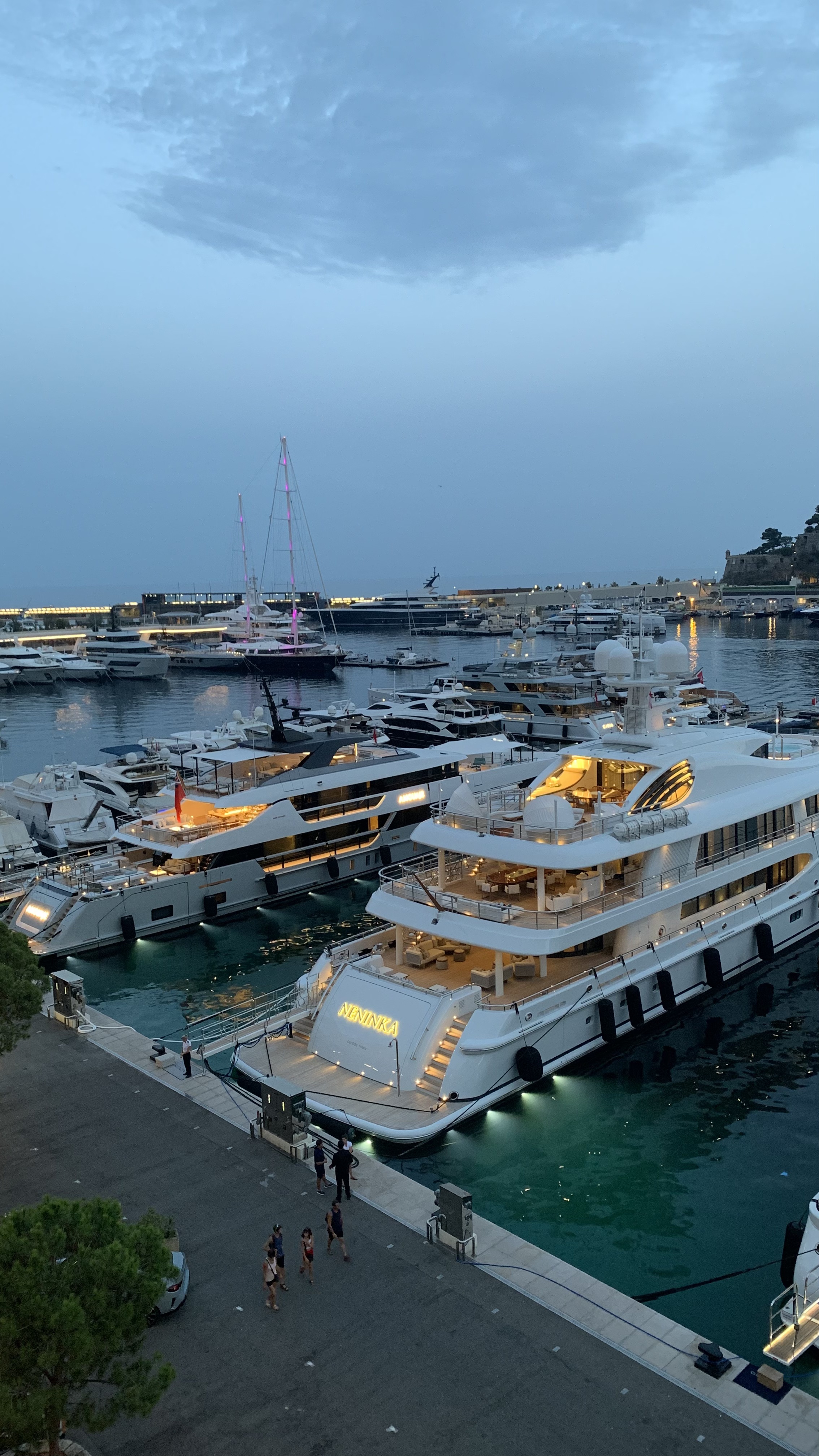
Location: Port Hercule · Monaco
Visual source: Monaco Visual Fieldwork Archive (MVFA)
Fieldwork: 2017–2026
Photograph: © Xavier Reinaldo-Virgili
Description: An elevated view showing port infrastructure, vessels and the waterfront promenade simultaneously, making the spatial relationship between the harbour and pedestrian circulation visible.
Research use: Waterfront morphology · panoramic observation · pedestrian-port relationship
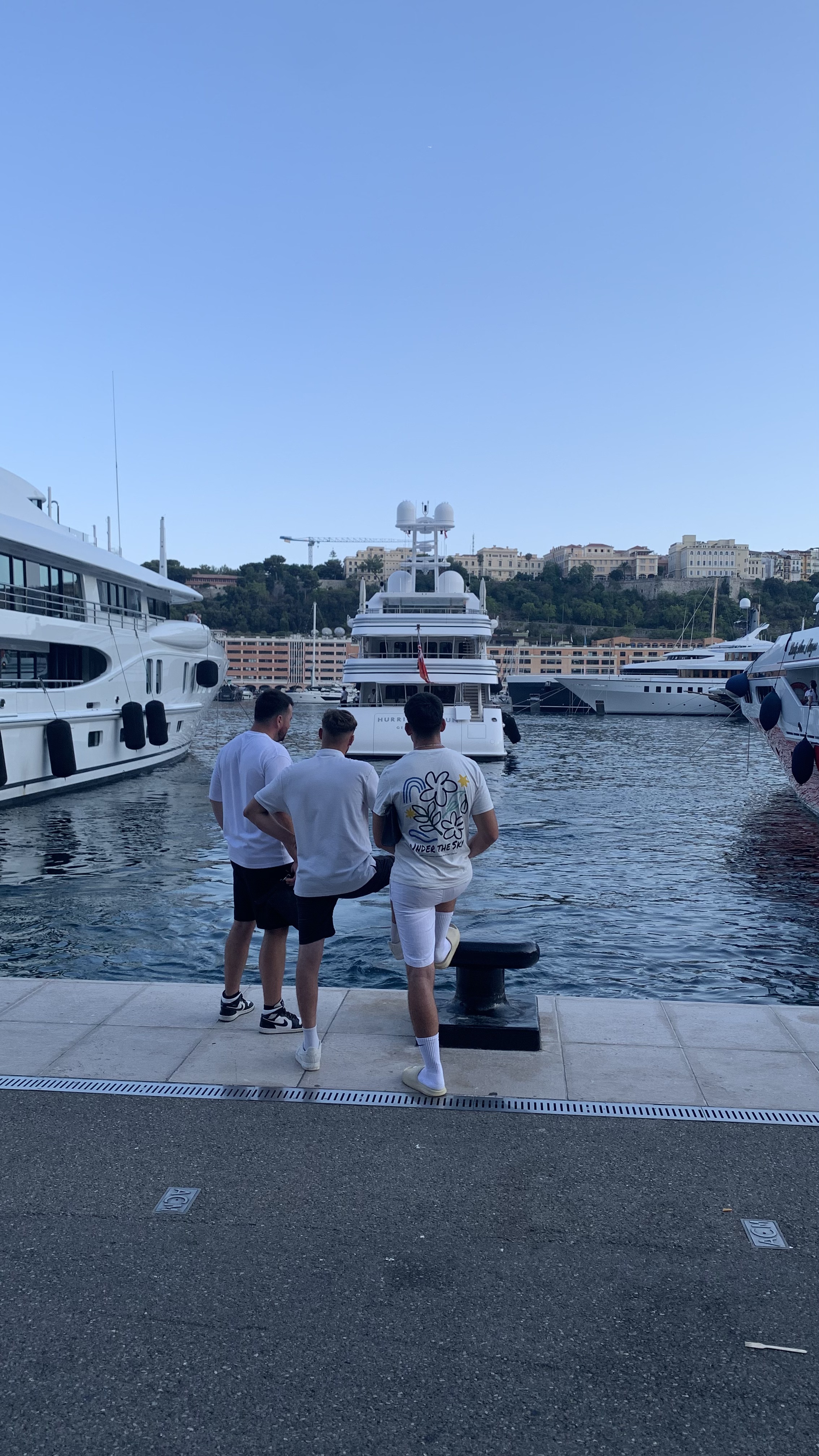
Location: Port Hercule
Visual source: Monaco Visual Fieldwork Archive (MVFA)
Fieldwork: 2017–2026
Photograph: © Xavier Reinaldo-Virgili
Description: A group of people stopped along the waterfront promenade, observing a yacht departing. The scene documents a visible relationship between public space, observation and maritime activity.
Research use: Tourist observation · stopping · yachting landscape · waterfront activity
Visual proximity to a vessel does not equate to access, use or ownership.
04 · Elevated & Panoramic Observation Height, movement and extended visual fields
Monaco’s topography creates numerous changes in elevation from which the urban landscape can be observed with varying degrees of visual openness.
The following records show that panoramic observation can occur both from stationary positions and along routes that progressively expand the visual field.
Location: Place d’Armes · La Condamine
Visual source: Monaco Visual Fieldwork Archive (MVFA)
Fieldwork: 2017–2026
Video Fieldwork: © Xavier Reinaldo-Virgili
Description: Panoramic view of the city and Port Hercule from the vicinity of Place d’Armes, showing the relationship between an elevated position, the urban fabric and the open view towards the harbour.
Research use: Panoramic observation · urban landscape · Port Hercule · elevation
Location: Avenue de Monte-Carlo · Monaco
Visual source: Monaco Visual Fieldwork Archive (MVFA)
Fieldwork: 2017–2026
Video Fieldwork: © Xavier Reinaldo-Virgili
Description: A route towards a position from which Port Hercule progressively enters the visual field. The video documents how movement alters the relationship between the observer, elevation and the harbour landscape.
Research use: Route observation · changing visual field · elevation · Port Hercule
Location: Monte-Carlo · Fairmont Hairpin
Visual source: Monaco Visual Fieldwork Archive (MVFA)
Fieldwork: 2017–2026
Video Fieldwork: © Xavier Reinaldo-Virgili
Description: People observing the Fairmont Hairpin from an elevated position. The record shows how a feature of urban mobility can also become an object of observation from a vantage point at a different elevation.
Research use: Elevated observation · mobility landscape · visual tourism · urban landmark
Location: Rampe Major · Monaco-Ville / Place d’Armes
Visual source: Monaco Visual Fieldwork Archive (MVFA)
Fieldwork: 2017–2026
Video Fieldwork: © Xavier Reinaldo-Virgili
Description: Panoramic view of the city and Port Hercule from Rampe Major, a route connecting Monaco-Ville with the area around Place d’Armes. The slope creates successive visual fields over the lower-lying urban landscape.
Research use: Topography · panoramic observation · route sequence · urban elevation
Location: Monaco
Visual source: Monaco Visual Fieldwork Archive (MVFA)
Fieldwork: 2017–2026
Video Fieldwork: © Xavier Reinaldo-Virgili
Description: A recording of people stopping to look at an urban panorama. The observation shows the relationship between spatial position, temporary stopping and visual access to the landscape.
Research use: Observation behaviour · panoramic landscape · stopping · visitor-space relations
An elevated position may expand what is visible, but it does not determine how each observer will interpret it.
05 · Urban Visual Encounters & Orientation Icons, objects and routes within the tourist city
Tourist observation is not limited to expansive panoramas. Particular buildings, moving objects and wayfinding devices may also structure the visual experience of a destination.
Place du Casino clearly illustrates this relationship: the casino façade is a recurring photographic subject, while certain vehicles may temporarily attract the attention of people occupying the square.
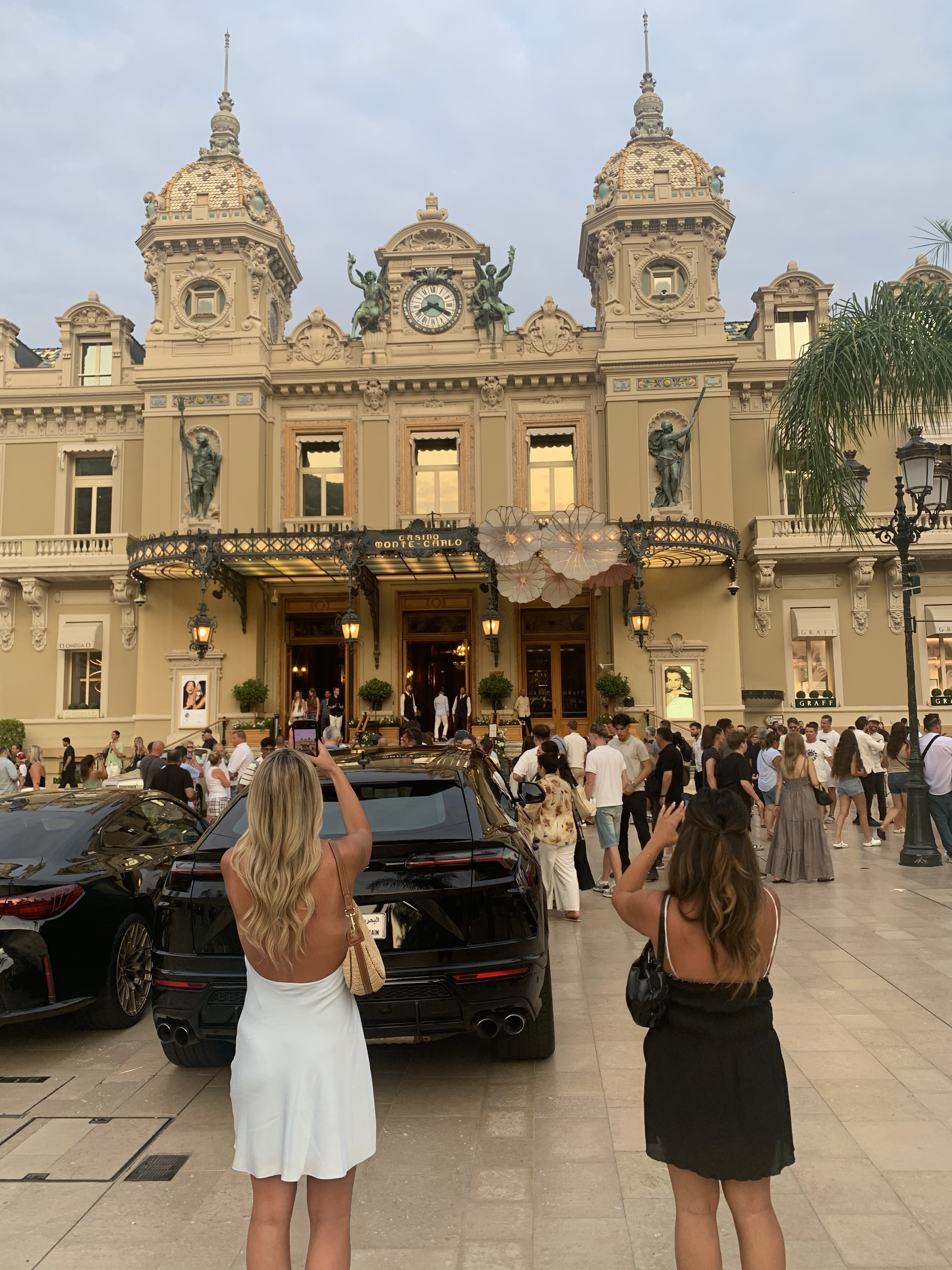
Location: Place du Casino · Monte-Carlo
Visual source: Monaco Visual Fieldwork Archive (MVFA)
Fieldwork: 2017–2026
Photograph: © Xavier Reinaldo-Virgili
Description: People photographing the Casino de Monte-Carlo from the front of the square, documenting a direct relationship between landmark architecture, observer positioning and the production of tourist images.
Research use: Tourist photography · landmark observation · destination imagery · visual behaviour
Location: Place du Casino · Monte-Carlo
Visual source: Monaco Visual Fieldwork Archive (MVFA)
Fieldwork: 2017–2026
Video Fieldwork: © Xavier Reinaldo-Virgili
Description: A high-value vehicle arriving at Place du Casino as several people photograph it. The record documents how a valuable moving object may temporarily become a visible focus of attention and image-making within a tourist space.
Research use: Luxury visibility · tourist photography · mobile visual object · Place du Casino
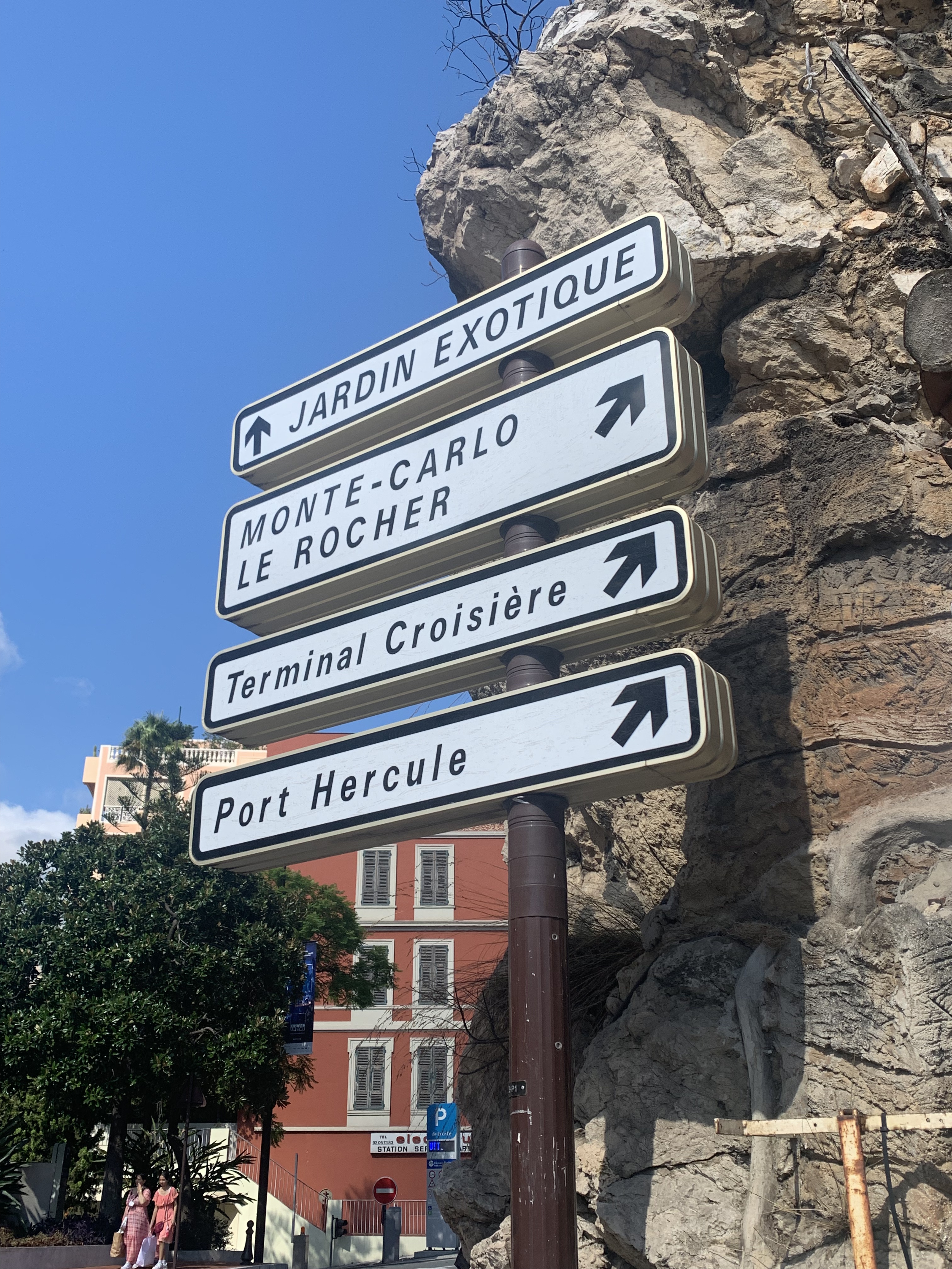
Location: Monaco
Visual source: Monaco Visual Fieldwork Archive (MVFA)
Fieldwork: 2017–2026
Photograph: © Xavier Reinaldo-Virgili
Description: Directional signage pointing towards Jardin Exotique, Monte-Carlo, Le Rocher, the cruise terminal and Port Hercule. The sign connects different tourist and functional nodes within a shared urban wayfinding system.
Research use: Wayfinding · tourist orientation · urban connectivity · destination structure
06 · Comparative Reading Different modes of visual encounter
The eleven records show that tourist observation may occur through markedly different spatial configurations.
| Observation Mode | Spatial Condition | Visible Relationship |
|---|---|---|
| Waterfront Observation | Quay · promenade · harbour edge | Observer ↔ yachts ↔ harbour activity |
| Panoramic Observation | Elevation · slopes · ramps | Observer ↔ extended urban field |
| Landmark Photography | Square · frontal viewpoint | Observer ↔ iconic architecture |
| Mobile Visual Encounter | Moving vehicle within tourist space | Observer ↔ temporary object of attention |
| Orientation | Directional signage | Visitor ↔ destination network |
07 · Tourism Interpretation Observation as a spatial practice
The collection makes it possible to examine observation as a spatial practice associated with tourist movement.
Observing the harbour from an elevated position, stopping in front of a yacht, photographing the Casino de Monte-Carlo or pointing a camera towards a vehicle entering Place du Casino are different behaviours, but all depend on a specific relationship between position, visual field and observed subject.
Wayfinding adds a complementary dimension: before observing particular places, visitors must be able to orient themselves within a territorial network of destinations, neighbourhoods, infrastructure and points of interest.
08 · Interpretative Limits What the visual evidence does not establish
Stopping ≠ demonstrated interest.
Photographing ≠ demonstrated admiration.
Visual proximity ≠ physical access.
High-value object ≠ universal tourist attraction.
Elevated position ≠ stronger subjective experience.
Observed person ≠ automatically demonstrated tourist.
Visual collection ≠ statistical representation.
The records show observable situations at specific moments, within particular frames and from particular positions. They do not allow the overall frequency of these practices to be estimated or the meanings that individuals attribute to what they observe to be determined automatically.
Monaco Visual Fieldwork Archive
The four photographs and seven video observations used in this Visual Collection come from the Monaco Visual Fieldwork Archive (MVFA).
The eleven records were selected for their usefulness in examining relationships between position, visibility, movement, observation, photography and tourist orientation.
The collection is a purposively selected set of visual records, not a statistically representative sample of all observation points or tourist behaviours in Monaco.
© Xavier Reinaldo-Virgili · Monaco Visual Fieldwork Archive (MVFA) · 2017–2026
10 · MVFA Documentation Archive documentation and public repository
The structure, scope and traceability principles of the Monaco Visual Fieldwork Archive are formally documented in:
MVFA — Broader Visual Fieldwork Collection: Scope and Documentation
Open the MVFA Broader Visual Fieldwork Collection Documentation →
OSF Research Repository:
Monaco Research Observatory — Visual Research Repository
11 · Methodological Status Scope of the collection
| Visual Research Format | Visual Collection |
|---|---|
| Record ID | VC-001 |
| Evidence Type | Fieldwork Photography · Video Field Observation |
| Number of Visual Records | 11 |
| Photographs | 4 |
| Video Observations | 7 |
| Source Archive | Monaco Visual Fieldwork Archive · MVFA |
| Research Approach | Thematic · Comparative · Spatial · Visual |
| VAM Assessment | No |
| SECP Assessment | No |
| Representativeness | Purposive Visual Collection · Not Statistically Representative |
12 · Related Visual Research Connections within the Monaco Research Observatory
|
Visual Research
Monaco Visual ObservatoryObservation · Photography · Visual Behaviour |
Visual Archive
Monaco Visual Fieldwork ArchivePhotography · Video · Provenance · Traceability |
|
Spatial Research
Monaco Spatial & Visual AtlasResearch Areas · Observation Points · Routes |
Related Visual Note
VN-002 · Luxury in the Everyday StreetscapeHigh-value objects · visibility · urban landscape |
A geography of tourist observation
The records show that observing Monaco depends not only on visiting a series of places, but also on occupying positions from which those places, objects and landscapes become visible.
Elevation expands visual fields; harbour edges bring vessels into closer visual proximity; squares provide opportunities to photograph architecture and moving objects; and signage connects these spaces within a territorial network.
The collection thus makes it possible to understand the visual experience of a destination as a relationship between position, movement, visibility, observation, photography and orientation, while keeping observable evidence distinct from subjective interpretation.

